HOT NEWS !
Stay informed on the old and most recent significant or spectacular
nautical news and shipwreck discoveries

-
HMS Hermes wreck shipshape for plunder
- On 18/07/2011
- In Parks & Protected Sites
From the Sunday Times
An underwater museum of WW II artefacts, housing exotic marine life, cries for protection from salvage pirates
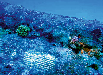
Lying in its watery grave, at a depth of a little over 50 meters off the East coast, the world's first aircraft carrier, HMS Hermes is Sri Lanka's star shipwreck.
Sunk by Japanese bombers during World War II, it is now attracting serious attention of both local and foreign divers. But there came disturbing news, where a recent investigation by the National Aquatic Resources Agency (NARA) has found attempts to remove one of the cannons off this wreck.
Photographs by NARA's underwater survey team chief Lucky Ginige show attempts to remove artefacts from the Hermes and the exposed data plate of one of her guns. Divers who explored the Hermes shipwreck say the main tower of Hermes broke at the impact of sinking, but overall, most of the ship is intact.
Several anti-aircraft guns, including a few canons are among the key features of the wreck that attract divers worldwide to this iconic shipwreck. Therefore, this shipwreck is a star attraction of Sri Lanka's dive-tourism, and dive operators highlight the need to preserve its present status.
In recent months, especially after the war, many shipwrecks have been salvaged for their scrap metal and artefacts. Plans are afoot for the salvage of many more sunken ships, but it is not prudent, point out marine experts, as these shipwrecks have become artificial Coral Reefs that support a variety of marine life. -
Divers find gold in Holyhead, as wreck gives up ghosts
- On 17/07/2011
- In Treasure Hunting / Recoveries
By Jasper Copping - The Independent
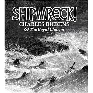
Treasure hunters have recovered gold from a Victorian shipwreck that sunk off Anglesey Island in Wales while returning laden with riches from the Australian gold rush.
For more than 150 years it has lain tantalisingly close to the shore. Now the ship that sank in a storm in 1859, claiming 450 lives, has given up its most precious secret: gold.
But this treasure trove is not in a distant tropical lagoon -- it is near the ferry port of Holyhead, in the remains of an iron-clad steam clipper called the Royal Charter.
A team of divers at the ship, which sunk off Anglesey while returning with riches from the Australian gold rush of the 1850s, has brought gold coins and nuggets to the surface and expects to find more.
The ship foundered on rocks just yards from the shore after a hurricane hit on the last leg of its journey from Melbourne to Liverpool in October 1859. On board were gold prospectors returning with their fortunes. By daybreak the ship had sunk and 450 passengers and crew, along with the gold, had been lost.
Vincent Thurkettle, a full-time gold panner who is leading the expedition, said: "We have got some gold dust, nuggets and coins as well as about 200 artefacts. And there is more gold down there."
The finds have all been reported to the Receiver of Wreck, who administers all shipwrecks. People connected to the passengers can claim ownership -- although claims are thought to be unlikely. The gold will then be returned to the team or sold to a museum, with a fee passed to the divers.
The treasure has yet to be valued and the team have declined to say how big their haul is. However, the value, particularly of the coins, will be inflated because of where they were found.
Mr Thurkettle said: "To have a coin from the Royal Charter will probably be worth double or treble what it would otherwise be worth."
His team of about 12 divers and gold panners have been visiting the wreck for the past seven summers, but only now have they agreed to reveal details. They estimate there's another two years' worth of exploring left. -
Uncovering the ‘good ship’ Warwick
- On 16/07/2011
- In Underwater Archeology

From The Royal Gazette Online
The loss of the good ship Warwick was not the only disaster that this cruel storm brought with it.It also meant the total ruin of the winter’s crop of corn, to such a great extent that all the inhabitants were very worried about a shortage of food.
They had good reason to be anxious, for even though the islands were prolific enough in every respect, and had two harvests every year, yet careless wastage had become the custom with most of the people’ C.F.E. Hollis Hallett, Butler’s History of the Bermudas, 2007
On October 20, 1619, the third governor arrived in Bermuda at the behest of the Somers Island Company, the corporation that owned the 12,000 acres of the island.
The gentleman was Captain Nathaniel Butler, who succeeded in his position the first governor, Richard Moore (1612-15) and the second, one Daniel Tucker (1616-18).
Perhaps the most dynamic of the three, Governor Butler shook the seven-year old settlement into some semblance of normalcy, establishing a parliament in 1620 (now one of the oldest in the world), erecting forts and encouraging people to build in stone by the erection of the State House in 1621.
For history, perhaps Butler’s greatest achievement was his written account of the first 12 years of the settlement of Bermuda, lately published in modern English by the National Museum of Bermuda.
It is from that account that we have firsthand information on the demise in November 1619 of the Warwick, the “magazine” ship of Robert Rich, the Earl of Warwick, who was one of the major shareholders of the Bermuda Company.
Having arrived six weeks or so earlier, Governor Butler recorded the disaster that befell the vessel that brought him to Bermuda:
“First came a terrible storm and hurricane, in which the Garland, riding at anchor in the King’s Castle harbour, which was very exposed to northwest winds, was forced for safety’s sake to cut down her mainmast to the ship’s side, and in this crippled state to ride out the storm for her life.
“But the Warwick, which was moored not far from the Garland, slipped all her anchors and was driven onto the rocks, and completely wrecked.”
Fast-forward three and a half centuries, when Mendel Peterson of the Smithsonian Institution and EB (Teddy) Tucker began an examination of the wreck of the Warwick, finding that a good part of one side of the vessel was preserved under a pile of ballast.
On that occasion, the expedition flew Flag #189 of the prestigious Explorers Club of New York.
In 2011, new work by the National Museum began on the shipwreck and Explorers Club member, Jason Paterniti, brought Flag #132 to the site in the southern reaches of Castle Harbour.
Previously, Flag 132 had been on Dr Robert Ballard’s search to find the German battleship, Bismarck, among other nautical projects.
The director of the new project, Piotr Bojakowski, has noted that “the 2011 Warwick excavation season has been an overwhelming success. It produced important information about how the vessel was designed, built, armed, rigged and what cargo it carried”.
For the project, the National Museum enlisted the assistance of experts in marine archaeology, who have been associated with the Mary Rose, Vasa and other shipwreck projects and they have given some opinions on the wreck of the Warwick. -
Major shipwreck survey off coast underway
- On 16/07/2011
- In High Tech. Research/Salvage

By Shawn J. Soper - MD Coastd Dispatch
A major effort is underway to identify and catalogue thousands of vessels shipwrecked off the U.S. coastline decades ago, including a vast area off Maryland’s coast, to determine which pose significant threats of breaking apart.
The National Oceanic and Atmospheric Administration (NOAA) this summer is undertaking an ambitious project to identify and catalogue as many as 30,000 vessels shipwrecked off the nation’s coast, many of which were sunk by German U-boats during World War II, that now pose a serious threat of corroding or breaking apart and dumping potentially harmful oil and other cargo into the ocean and ultimately onto the nation’s beaches.
Some were shipwrecked in storms while others collided with other vessels and sank.Quite a few more were torpedoed by German U-boats during the Battle of the Atlantic waged off the mid-Atlantic coast during World War II, taking their potentially harmful cargo to the bottom of the sea just a mere few miles from the Ocean City coast in many cases.
Decades later, the sunken vessels are showing signs of corroding and breaking up, creating potentially harmful oil spills that could find their way to beaches throughout the mid-Atlantic, including Ocean City. In response, NOAA has embarked on a project to identify the thousands of wrecks and create a prioritized list of those most likely to need monitoring or proactive mitigation.
“This is an issue the federal government is working on,” said Lisa Symons, Damage Assessment and Resource Protection Coordinator for NOAA’s Office of Marine Sanctuaries this week.“A lot of vessels went down with the their fuel tanks full and with potentially harmful cargo on board. Once these vessels reach 60 or 70 years old, they start to break down and deteriorate and can cause a whole lot of problems.”
Symons said NOAA is preparing a list of all potentially harmful wrecks in U.S. waters all over the country, including the mid-Atlantic and the area off Maryland’s coast, where a handful of wrecks have already been identified.
“We have a list for all U.S. waters and we’re going through that list vessel by vessel and see what if any remediation efforts are necessary,” she said. “Through our survey, we’re trying to find out what happened to them, what their current status is, and what, if any, salvage efforts are required.”
The working list includes several wrecks off the mid-Atlantic coast including Maryland. For example, the unarmed and unescorted “W.L. Steed,” an oil tanker carrying 66,000 barrels of crude oil was torpedoed by a German U-boat about 90 miles off Maryland’s coast in February 1942. In another example off the mid-Atlantic coast, the Norwegian tanker “Varanger” was carrying 12,750 tons of fuel oil when a German U-boat fired a torpedo into her hull and sank the vessel about 28 miles southeast of Atlantic City, N.J. in January 1942.
The unescorted and unarmed “India Arrow,” carrying 88,000 gallons of diesel fuel, was torpedoed and sunk during World War II just 20 miles southeast of Cape May, N.J. In a more contemporary example not related to World War II, the 607-foot “Marine Electric” went down in a fierce winter storm in 1983 just 30 miles off the coast of Chincoteague, taking its cargo of 25,000 tons of coal to the bottom off Maryland and Virginia’s coast.
Symons said those vessels and countless others are being explored to determine their current condition and what, if any, environmental threats they pose as they continue to deteriorate and break up.
“We’re going to identify where they are and what might be aboard still,” she said. “We’re gathering the information and try to prioritize the list to determine which vessels are or aren’t a potential threat.”
-
'World's oldest' wreck found in Swedish Baltic
- On 16/07/2011
- In Underwater Archeology

From The LocalWhat looks very much like a cog, a ship used in the Baltic between the 12th and the 14th centuries, has been discovered in the waters between the islands of Gotland and Öland off the east coast of Sweden.
The vessel showed up in sonar pictures of the area, causing experts on shipwrecks to believe that they may have the world’s oldest intact shipwreck on their hands.
“The hairs at the back of my neck stood up when I first saw the pictures,” said shipwreck expert Erik Bjurström to the local Barometern daily.
Because of the age of the ship and the location, historians cannot but wonder if it in fact could be the legendary ship that carried the Danish king Valdemar Atterdag home after his sacking of Visby on Gotland, in 1361 AD.
"There is a theoretical possibility that it is Atterdag's ship," said Richard Lundgren at exploration firm Ocean Recycling to The Local on Friday.
Wanting to limit the power of the hanseatic trade league in the area, King Valdemar IV of Denmark decided to attack the Baltic island of Gotland. According to legend he hated the Gotlanders and especially the city of Visby, where he had heard that they had made up songs to mock him.
Once in possession of the city of Visby, the Danish king, wanting to humble the burghers, allegedly set up three huge beer barrels saying that if the barrels weren't filled with silver and gold within three days, he would turn his men loose to pillage the town.
But the barrels were filled before nightfall of the first day and after the churches had been stripped of their riches, the loot was loaded on Danish ships and carried home.
However, one ship was lost on the way and although sought by many a shipwreck expert, it has never been found.
After studying the images Bjurström it is almost certain that what the sonar showed is a medieval cog.
The discovered ship was found at a depth of 100 metres in a secret location between the two Baltic isles. The sonar pictures show a small vessel, 28 metres long and seven metres wide. -
2 shipwrecks found in Lake Huron
- On 15/07/2011
- In Wreck Diving
By M.F. Merrick and Etruria - Wood TV
A team of underwater explorers has found two long-lost shipwrecks in northeastern Lake Huron.
Thunder Bay Marine Sanctuary on Wednesday announced the discovery of the schooner M.F. Merrick and the steel freighter Etruria in deep water off Presque Isle.
They were detected during an expedition called "Project Shiphunt," which involved scientists and historians from the National Oceanographic and Atmospheric Administration and five high school students from Saginaw.
Both ships sank after colliding with steamers in dense fog.
The 138-foot-long Merrick went down in 1889. Five crew members were killed. The intact hull was found resting upright on the lake bottom.
The Etruria, which was 414 feet long, sank in 1905 -- just three years after it was launched.
A documentary about the expedition will be released Aug. 30.
-
Eastbourne divers to act as guardians of wreck
- On 15/07/2011
- In Wreck Diving
From the Eastbourne Herald
Sovereign Divers are to act as guardians of a shipwreck in Normans Bay dating from around 1700.
The Eastbourne’s branch of the British Sub-Aqua Club has been asked by the Nautical Archaeological Society (NAS) to watch over the wreck which lies a few miles off the coast of Normans Bay.
It is thought to be HMS Resolution, a British warship which sank in the Great Storm of 1703, or one of seven Dutch warships that went down during the Battle of Beachy Head in 1690. In either case, it is of historical importance and is designated as a protected wreck, meaning that no diving or fishing can take place within 100 metres of the site.
So far more than 42 cannons and a number of other artefacts including a large anchor have been found. Unfortunately, the ship’s bell and other items which would give a positive identification of the shipwreck have yet to be found.
Only divers who are licensed by the NAS and English Heritage may dive on the wreck and Sovereign Divers has been asked to keep a watchful eye on the site to make sure only authorised diving takes place.
The NAS has also started to survey the site in detail and aims to offer authorised divers a trail so they can find the main points of interest on the wreck such as the cannons and the remains of what is thought to be the ship’s galley.
Graham Smith, chairman of Sovereign Divers, said, “This is a fantastic collaboration between us and the NAS.
“The wreck is only three miles from our harbour and we aim to make regular trips to the site and to assist the NAS and English Heritage in monitoring and recording this historic wreck.”
Full story... -
Maroubra shipwreck hidden gem
- On 13/07/2011
- In Wreck Diving

Photo Glenn Duffus
By Nick Moncrieff-Hill - Southern Courier
A still winter’s day has given a group of lucky snorkelers a window into the maritime history of Maroubra.
Usually known for its above surface delights Maroubra showed off one of its hidden gems recently in the wonderfully preserved wreckage of the Hereward.The 1,513 tonne, 254 foot iron clipper built in Glasgow in 1877 made frequent trips between London and Sydney as a trading ship with general cargo.
Until, on a trip from the Dutch East Indies to Newcastle on May 5 1898 to load coal for South America, the Hereward was whipped by 47 mile per hour winds onto the northern end of Maroubra beach.
Thousands of sightseers visited the wreck before it was sold for 550 pounds. Then after several attempts to refloat her, the Hereward was eventually broken in two by the Maroubra surf.
Maritime archaeologist at the Australia National Maritime Museum Kieran Hosty confirmed the shipwreck was likely that of the Hereward.
“There are three known shipwrecks on Maroubra Beach; the Belbowrie 1939, Tekapo 1899 and the Hereward 1898,” Mr Hosty said.
“The photographs show part of the lower hull and side of a late 19th century early 20th century iron or steel hulled ship.
“The absence of an engine, boiler and propeller seems to indicate that it was a sailing rather than a steam vessel ... I suggest the remains belong to the iron sailing ship Hereward.”
The photographer, Maroubra local Glenn Duffus said the conditions to view the wreck were the best he’d seen them for years.