HOT NEWS !
Stay informed on the old and most recent significant or spectacular
nautical news and shipwreck discoveries

-
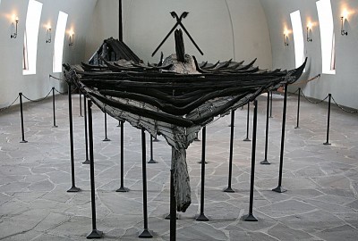
Viking ship not just ceremonial
- On 12/05/2011
- In Museum News
By Nina Berglund - News In English
For years, it was widely believed that the ancient Tune ship on display at the Viking Ships Museum in Oslo was used mainly as a so-called “grave ship,” perhaps even built for the purpose of being buried in the grave of an important Viking.Now a new doctoral dissertation claims that it was not only an ocean-going sailing vessel, but even grounded in its time and underwent repairs.
The Tune ship is the lesser-known and in the poorest condition of the three vessels on display at the museum. It was discovered on a farm on Rolvsøy, north of Fredrikstad, and excavated from a burial mound in 1867.
The grave was unusually large, measuring 80 meters in diameter and around four meters high, according to the Museum of Cultural History at the University of Oslo. The vessel, built around 900AD, was best preserved in the areas where it had been buried under thick clay.
Its remnants, however, paled when the stately Gokstad ship was discovered in 1880 and the Oseberg ship in 1903-04 on the other side of the Oslo Fjord. Now, archaeologist Knut Paasche of the Norwegian Institute for Cultural Heritage Research (NIKU) maintains in his newly finished doctoral dissertation that the Tune ship was also used on the high seas.
“Six planks forward on the starboard side are extended at the same place,” Paasche told newspaper Aftenposten this week. “No boatbuilder would do that, not even in Viking times. Repairs to the hull show in all clarity that the ship was damaged under the water line, that is, it had grounded.”
Paasche doesn’t believe the Tune ship was a ceremonial ship that only was rowed inland until it was brought ashore and used in the burial mound.His studies revealed both ruts and signs of wear and tear under the keel, which he contends show that the ship was in use for a long time.
“The discoveries show that the Tune ship was in use for several years before it wound up in the grave,” he told Aftenposten -
Missing German WWI U-boat Discovered
- On 11/05/2011
- In High Tech. Research/Salvage

From Hydro International
A Hydroid REMUS 100 AUV aided in the discovery of the World War I German submarine U-106, which had been missing since October 1917. The Royal Netherlands Navy (RNLN), which used the REMUS vehicle, located the missing submarine off the coast of Terschelling in the Netherlands.In October 2009 the RNLN hydrographic survey vessel HNLMS Snellius located an unidentified object while charting shipping lanes. This was followed two months later by an inspection by a MCMV, the HNLMS Maassluis.
A wire-guided Remotely Operated Vehicle (ROV) designed to locate mines, detected the shape of the vessel. The discovery prompted a series of research missions, which employed Hydroid’s REMUS 100 as well as divers from the Royal Netherlands Navy’s Diving and Explosive Ordnance Disposal Group (EOD).The REMUS vehicle and the EOD divers descended 40 metres in order to explore the area, where a brass plate bearing the serial number of the submarine was eventually discovered.
After further exploration as well as confirmations from the German Ministry of Defense and the families of crew members, the submarine was positively identified as the German U-106, which perished during the First World War."These findings always happen by chance,” said expedition leader Captain-lieutenant Jouke Spoelstra. “Twelve years ago, a hydrographic survey ship passed the same spot of our discovery, but the German vessel must have still been under a layer of sand. We were lucky to be at the right place at the right time.”
-
Shipwrecks off Tg. Tuan may contain historical treasure
- On 11/05/2011
- In Parks & Protected Sites
From The Star
The state government is attempting to salvage dozens of shipwrecks found off the coast near Tanjung Tuan here, which may yield artefacts worth billions of ringgit.
State Tourism, Culture and Heritage committee chairman Datuk Latiff Tamby Chik said the shipwrecks, some of which were 500 years old, were discovered during a survey conducted by the National Heritage Department and Royal Malaysian Navy.
“Some of these vessels could be from the time of the Malacca Sultanate and some from the period between 1600s and 1800s.
“It's an important find with rich historical value for Malacca,” said Latiff after visiting Hang Li Poh Well here yesterday.
The shipwrecks were located on the seabed some 100m from the surface, he added.
Latiff said authorities believed the shipwrecks could include Raja Haji and Bulan Linggi, two vessels used by the Malay rulers between 1600 and 1650.
Most, he added, were probably merchant ships on their way to Malacca before they sank.
“The cost of salvaging one of these ships could cost up to RM3mil but the artefacts recovered can reach up to billions of ringgit,” he said, adding that the state government was trying to salvage the wrecks with the help of foreign deep-sea recovery companies.
-
Valuable Titanic memorabilia washes up at Heritage
- On 10/05/2011
- In Auction News
From Paul Fraser collectibles
A fragment from the hull of the doomed vessel and a pair of Titanic lifebelts are up for sale
An actual 7 x 4 inch section from the hull of the doomed ship R.M.S. Titanic, modern history's most famous shipwreck - consigned by famous author, Hollywood consultant and deep sea archeologist Charles Pellegrino - is expected to bring $4,000+ as part of Heritage Auctions' May 21 Americana & Political Memorabilia event. A minimum of 10% from proceeds will be donated to the Firefighter's Burn Centre.
"This is the first time these relics have ever been offered," said Tom Slater, Heritage's Director of Americana, "Pellegrino, one of the world's foremost experts on the doomed ship, has chosen now to share this treasure with the world, and we expect that collectors will be clamoring for a chance to make this theirs."
The actual wreck of the Titanic is, of course, strictly protected, making portions of the ship itself virtually unavailable in the private market (and a strong investment).This section, however, was part of the "crackage" of the great boat, which sheared away from the vessel as it broke in half, and was recovered from the ocean floor some distance from the wreck.
A semicircular depression in one corner of the piece is evidence of the force with which the ship cracked, sufficient to pop a rivet completely away from the hull. It has become essentially fossilized after the bio-absorption.
Also included in Pellegrino's consignment is a fossil impression of rope from H. M.S. Titanic measuring 1.5" x 2", in which original rope strands became imbedded, found inside rusticle formations growing around the davit bit (the rib or buttress-like appendage from which lifeboats were suspended) that was used to lower the #8 lifeboat, expected to bring $4,000+, along with a 2.5" sample from the railing of the Titanic's "#8 Lifeboat" davit, also estimated at $4,000+.
A minimum of 10% of the proceeds of these lots will also be donated to the Firefighter's Burn Centre.
"The #8 Lifeboat railing is particularly significant," said Slater. "The Titanic's band played near this location and this is also where Mrs. Isador Strauss gave her maid, Ellen Bird, her fur coat, saying she would not be needing it, then stepping away from the boat and joining her husband behind the rail saying, 'Where you go, I go.'"
-
Torrey Canyon seabed returns to normal after oil spill
- On 08/05/2011
- In Wreck Diving

From BBC News
The seabed off the Cornish coast seems to have almost recovered after an oil tanker spill in 1967, writes Paul Rose, expert diver and presenter on BBC programme Britain's Secret Seas.
The Torrey Canyon is the largest shipwreck in British waters, and as she sits a long way from shore amongst the same hazardous rocks that she ran on to, its not the easiest wreck to get to.
On Saturday, 18 March 1967, she ran aground carrying over 119,000 tonnes of crude oil, which gushed out into the pristine Atlantic waters.
She had run into one of the infamous Seven Stones rock pinnacles, which lay 15 nautical miles west from Lands End and seven nautical miles from the Scilly Isles, which make it a hard wreck to reach.
We believe our team is the first to film the wreck, which is in an area often hit by storms. As I rolled off the boat into heaving waters caused by constant huge Atlantic swells, I entered a great swaying underwater forest of kelp.
The water was gin clear and the huge kelp fronds were in a mad rhythm of bending, then standing straight up, swinging and heaving to the forces of the sea.It was a great, vibrant start to the dive, but it looked to me as if we had missed the Torrey Canyon completely, as after all she is said to be well broken up over 2 sq km of the seabed.
I then realised that I was on the wreck - the huge hull plates have so much life on them that they look just like rocks or the bottom. The sea has reclaimed the wreck and it is teeming with life.
Things started to make sense and as I swam along the steel plates I joined large schools of wrasse, pollock and pouting.Some of the schools were moving purposefully along the wreck sides and others had relaxed into shoals underneath and inside the wreckage.
-
Battle to save remains of 400-year-old wreck
- On 08/05/2011
- In Underwater Archeology
By Emily Dugan - The Independent
A 17th-century shipwreck described as the "biggest discovery since the Mary Rose" is rotting so rapidly that it could disappear within five years.
The remains of the ship, known simply as the Swash Channel Wreck, were preserved for centuries under the seabed in six metres of water off the Dorset coast.But now its ornately carved timbers, the earliest still in existence in Britain, are literally being eaten away.
The sand that protected it has been shifted by changing currents and tides, leaving the 40m vessel's timbers exposed to bacteria and the tunnelling of aquatic shipworms.Tests on the timbers and artefacts trace the ship's history back to Europe in the early 1600s, where it was probably engaged in the beginnings of international trade with the Far East.
A Bournemouth University marine archaeology team has been studying the wreck since 2006. But they are now so concerned at its deterioration that they have decided to raise and preserve part of the hull next month .
David Payton, senior lecturer in marine archaeology at the university, said: "The damage there has increased dramatically since we first started studying it.It's a race – you've only got a certain amount of time before it's too late and there's no point.
"It's been buried until now, but in the last four or five years it's become exposed.The longer the wreck is exposed, the more damaged it will be. If nothing were done within the next five years there'd be nothing left."
-
Diver searching near Malta for St. Paul's shipwreck
- On 06/05/2011
- In Ancien Maritime History
By Kay Campbell - Chron
Even long before the times of Jesus and the Apostle Paul, Malta was the rocky knob at the western edge of the Roman Empire, the place where the leftovers of the Mediterranean Sea washed up and dug in.
And Malta is the site of what Huntsville software salesman John Harkins thinks will be the last and best quest of his life.
Harkins, a mild-mannered, Bible-reading, Church of Christ deacon and marine biologist, is determined to be the first person since the biblical Luke to see evidence of the ship that carried Paul nearly to Rome.
"I'm quite in the minority in thinking there might be some remnant," Harkins said, unrolling charts of the island on his desk at work. "But I know we're going to find something, though it may not be from Paul's wreck."
According to Acts 27, a chapter in Luke's history of the nascent Christian movement, a huge ship loaded with grain, sailors, soldiers, prisoners and passengers crashed into the coast at the end of a 14-day storm.
The ship broke in half, spilling everyone into the sea. Miraculously, the entire crew was able to struggle to shore, where they were met by the inhabitants of the 200-mile-long island, who built them a fire.
"The natives showed us unusual kindness," Luke writes.
Harkins said Malta's government places a high value on caring for and understanding relics washed on its shores. Museums catalog ancient weapons, structures, tools and, of course, fragments of the shipping trade that made Malta a crucial outpost of vessels attempting to round the Italian boot to get to Rome.
"God put that ship there, and I figure he put it where he wants it," Harkins said. "He gave it to the Maltese people, and frankly, he couldn't have given it to people who do more to preserve their heritage — and it's their heritage, along with the rest of us."
Harkins can't remember a time when the story of Paul's shipwreck didn't fascinate him. It was one of the stories that leapt out of the dim and musty antiquity of ancient stories to snap into Technicolor. -
Aerial surveys of Viking shipyard on Skye
- On 06/05/2011
- In Parks & Protected Sites

From BBC News
Aerial surveys are being carried out over Skye to help archaeologists investigate a 12th Century Viking shipbuilding site.
Boat timbers, a stone-built quay and a canal have already been uncovered at Loch na h-Airde on Skye's Rubh an Dunain peninsula.
The Royal Commission on the Ancient and Historical Monuments of Scotland (RCAHMS) has launched the air surveys.
Staff hope to pinpoint new sites for investigation.
Working with marine archaeologists, RCAHMS also hope to find potential dive sites for searches for the remains of ships and other artefacts.
Archaeologists now believe the loch was the focus for maritime activity for many centuries, from the Vikings to the MacAskill and Macleod clans of Skye.
RCAHMS said the loch and canal would likely have been used for protecting boats during winters and also for their construction and maintenance.Colin Martin, a marine archaeologist specialising in ship wrecks, has been investigating Loch na h-Airde.
He said: "This site has enormous potential to tell us about how boats were built, serviced and sailed on Scotland's western seaboard in the medieval period - and perhaps during the early historic and prehistoric eras as well.
"There is no other site quite like this in Scotland."
RCAHMS aerial survey manager Dave Cowley said the sea had been vital for connecting communities in the past.
He added: "The aerial perspective gives us an excellent sense of this, showing the inter-relations of land and sea, and helping us to understand how people may have travelled, traded - and fought - on the waters around Scotland's western isles."
In 2009, a crofter uncovered an ancient anchor while digging a drain on the Isle of Skye.