HOT NEWS !
Stay informed on the old and most recent significant or spectacular
nautical news and shipwreck discoveries

-
Los secretos del tesoro de la 'Mercedes'
- On 12/03/2012
- In Illegal Recoveries

La Gaceta
Cómo se hizo el mayor expolio de patrimonio español y por qué se simuló que procedía de la fragata ‘Mercedes.El 25 de febrero aterrizaron en la base de Torrejón dos aviones Hércules del Ejército del Aire con el tesoro extraído del mar por la compañía Odyssey Marine Exploration y cuya pertenencia a España reconoció el Tribunal de Tampa (Florida) el 22 de diciembre de 2009.
La Gaceta destapó en exclusiva la exportación de ese patrimonio español desde Gibraltar el 17 de mayo de 2007 y desde entonces hemos liderado la información sobre los secretos de este complicado caso.
Primer secreto: Gibraltar
Cuando presentó en Tampa el tesoro el 18 de mayo de 2007, Odyssey pretendió ocultar su procedencia. Dos días antes, el juez competente les había reconocido la propiedad de un pecio (yacimiento submarino) en aguas internacionales y el hallazgo de otro 100 millas al oeste de Gibraltar.
En Estados Unidos, la Ley del Almirantazgo reconoce a cualquier rescatador la propiedad de lo que se encuentre en el mar, si se prueba que ha sido abandonado por sus propietarios.
Odyssey declaró que, por razones de seguridad, no mencionaría el lugar donde extrajo el tesoro.
Cuando el 22 de mayo La Gaceta publicó la fotografía del avión con el que Odyssey había volado desde Gibraltar, la compañía cambió su versión de la historia, añadiendo que “las monedas se introdujeron en EE UU con una licencia de exportación válida garantizada por el país desde donde fueron exportadas e importadas legalmente conforme a las leyes de EE UU”.
La Gaceta publicó el 23 de mayo que el jefe de la aduana gibraltareña, John Rodríguez, había firmado las licencias, lo que confirmó la Embajada británica en Madrid, al asegurar que entre las competencias de su colonia está la de exportar por vía aérea metales preciosos.
La Embajada aseguraba que la extracción del tesoro se había realizado en aguas internacionales y que Odyssey había “confirmado a las autoridades británicas que está trabajando con la mayor celeridad posible para averiguar la identidad del barco hundido”. -
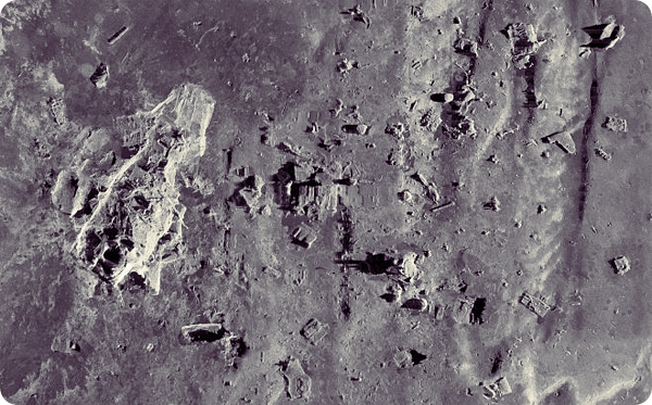
3D map of Titanic shipwreck may help scientific inquiry
- On 11/03/2012
- In Famous Wrecks
By Colin A. Young - Articles Boston
A group of scientists say they have stitched together the most detailed map of the Titanic shipwreck in hope of learning more about what happened on the night the ship sank.
Using the latest sonar and computer-imaging technologies, researchers recorded the entire site with new detail, clarity, and accuracy.
“Every expedition has enjoyed images of Titanic, but it has always been the bow, anchor, bridge, and specific items from Titanic,’’ David Gallo, a co-leader of the 2010 expedition, said Friday in a telephone interview.
“This is first time we’ve been able to put it all together.’’
Gallo - director of special projects at the Woods Hole Oceanographic Institute in Falmouth, one of the expedition partners - said the 3D map allows researchers to view the wreckage, which lies 2 1/2 miles beneath the surface of the sea, as a whole for the first time, not just as scattered puzzle pieces.
“We have the ability to see Titanic as it sits on the sea floor, and we can see it in the context of the sea floor surrounding it,’’ he said. “That’s a first for us.’’
Gallo’s Woods Hole team was joined by teams of scientists from the Waitt Institute in La Jolla, Calif., the National Oceanographic and Atmospheric Administration, the National Park Service, and the History Channel.
The latter will show a special program about the expedition and its findings on April 15, the centennial of Titanic’s plunge.
Two types of underwater vehicles were used to capture the 3-by-5-mile debris field: robot submersibles and remotely operated submersibles. Gallo said the robot underwater vehicles worked like “incredibly precise lawnmowers’’ to capture every inch of the wreckage.
-
El infiltrado que destapó el gran expolio de Odyssey
- On 11/03/2012
- In Illegal Recoveries

Jesus Garcia Calero - ABCUn español estuvo infiltrado en la red de intereses de Odyssey en el Estrecho de Gibraltar.
Pero informaba mientras tanto a la Unidad Central Operativa de la Guardia Civil. Los cazatesoros querían captarlo porque es buzo profesional y conoce bien la Bahía de Algeciras, donde ha llegado a encontrar piezas de valor.
Además, tenía un puesto importante en 2007, meses antes del expolio de Odyssey: director de proyecto de la monoboya de la refinería de Cepsa en Algeciras y director de operaciones de la empresa internacional PM Diving.
Pero en poco tiempo su vida se convirtió en un infierno: perdió su trabajo y tuvo que convivir con amenazas de muerte. Durante cinco años no ha querido hablar más que con la Guardia Civil. Hoy, por fin, rompe su silencio para ABC.
Todo comienza a principios de 2007, en un restaurante de Los Barrios, junto a Algeciras. Allí se celebra una comida muy especial.
Preside el encuentro Greg Stemm, el sonriente y dadivoso co-fundador de Odyssey Marine Exploration, que está extendiendo una fina red en la zona mientras sus barcos escanean las aguas territoriales del Mar de Alborán.
Serán doce personas en el almuerzo, divididas en dos mesas. Junto a Stemm, hay algún otro miembro del staff de la compañía, el dueño de PM Diving, Henrik Jensen, y también el contacto de confianza de Odyssey en España, un empresario gibraltareño residente en Sotogrande, Paw René Jakobsen. Completan las mesas los empleados de este último. Han invitado al buceador profesional de brillante carrera con el fin de ganarse su confianza y colaboración. ¿Por qué?
Se llama José Antonio Braza. Él había comentado detalles de sus inmersiones en conversaciones informales con Paw René y éste rápidamente lo puso en contacto con Stemm y Odyssey.
Tienen muchas ganas de saber dónde puede haber naufragios con cargas valiosas.
-
Sinking of the RMS Titanic: 100-year anniversary in the news
- On 10/03/2012
- In Famous Wrecks
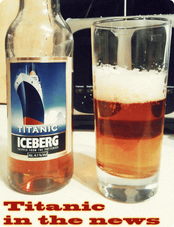
By Monkey Fist - gCaptainAs we approach the one hundredth anniversary of the sinking of the RMS Titanic, your humble author has noticed a good amount of Titanic-related news on the web this week. Included below, a sampling — in no particular order.
-
Why the Titanic still fascinates us ?
- On 10/03/2012
- In Famous Wrecks

By Andrew Wilson - Smithsonian Magazine
Dorothy Gibson—the 22-year-old silent film star— huddled in a lifeboat, dressed in only a short coat and sweater over an evening gown. She was beginning to shiver.
Ever since it had been launched, at 12:45 a.m., Lifeboat 7 had remained stationed only 20 yards away from the Titanic in case it could be used in a rescue operation.
Dorothy and her mother, Pauline, who had been traveling with her, had watched as lifeboat after lifeboat left the vessel, but by just after 2 o’clock it was obvious that the vast majority of its passengers would not be able to escape from the liner.
Realizing that the ship’s sinking was imminent, lookout George Hogg ordered that Lifeboat 7 be rowed away from the Titanic. The risk of being sucked down was high, he thought, and so the passengers and crew manning the oars rowed as hard as they could across the pitch-black sea. Dorothy could not take her eyes off the ship, its bow now underwater, its stern rising up into the sky.“Suddenly there was a wild coming together of voices from the ship and we noticed an unusual commotion among the people about the railing,” she said. “Then the awful thing happened, the thing that will remain in my memory until the day I die.
Dorothy listened as 1,500 people cried out to be saved, a noise she described as a horrific mixture of yells, shrieks and moans. This was counterpointed by a deeper sound emanating from under the water, the noise of explosions that she likened to the terrific power of Niagara Falls. “No one can describe the frightful sounds,” she remembered later.
Before stepping onto the Titanic, Dorothy Gibson had already transformed herself from an ordinary New Jersey girl into a model for the famous illustrator Harrison Fisher—whose lush images of idealized American beauty graced the covers of popular magazines—and then into a star of the silent screen.
-
Researchers map entire debris field of Titanic shipwreck
- On 09/03/2012
- In Famous Wrecks

By Clarke Canfield - Twin CitiesResearchers have pieced together what's believed to be the first comprehensive map of the entire 3-by-5-mile Titanic debris field and hope it will provide new clues about what exactly happened the night 100 years ago when the superliner hit an iceberg, plunged to the bottom of the North Atlantic and became a legend.
Marks on the muddy ocean bottom suggest, for instance, that the stern rotated like a helicopter blade as the ship sank, rather than plunging straight down, researchers told The Associated Press this week.
An expedition team used sonar imaging and more than 100,000 photos taken from underwater robots to create the map, which shows where hundreds of objects and pieces of the presumed-unsinkable vessel landed after striking an iceberg, killing more than 1,500 people.
Explorers of the Titanic - which sank on its maiden voyage from Southampton, England, to New York City - have known for more than 25 years where the bow and stern landed after the vessel struck an iceberg.
But previous maps of the floor around the wreckage were incomplete, said Parks Stephenson, a Titanic historian who consulted on the 2010 expedition. Studying the site with old maps was like trying to navigate a dark room with a weak flashlight."With the sonar map, it's like suddenly the entire room lit up and you can go from room to room with a magnifying glass and document it," he said. "Nothing like this has ever been done for the Titanic site."
-
Artifacts recoveries on shipwreck just in time to mark anniversary of sinking
- On 09/03/2012
- In Famous Wrecks
By McClatchy - Oregon Live
There are hundreds of shipwrecks along North Carolina's treacherous coast, and some, like those of the ironclad USS Monitor or the Blackbeard flagship Queen Anne's Revenge, are nothing short of famous.
But that of the hapless Civil War blockade runner Modern Greece, which sits just beyond the surf near Fort Fisher, is in many ways the most important of all.
The wreck, which was excavated 50 years ago, led to the creation of the state underwater archaeology unit that studies the other wrecks.
It led to a state law to protect historic wreck sites from pilfering. It yielded such a large trove of artifacts that many have been used in experiments that advanced the tricky science of how to preserve historical treasures found underwater.As the first of about 30 blockade runners sunk along the coast near Wilmington while trying to bring arms and vital commodities to the Confederate states, it has an iconic status in North Carolina and maritime history.
And this week _ just in time for events marking the 150th anniversary of its sinking _ thousands of artifacts from the Modern Greece were recovered from underwater.
For the second time.
A team of East Carolina University graduate students and University of North Carolina, Wilmington interns sponsored by the Friends of Fort Fisher waded into the muck of half-century-old storage tanks at the Department of Cultural Resources' Underwater Archaeology Branch facility on the grounds of the historic fort.
Their job: pull out the artifacts, clean and catalog them and put them in indoor tanks where they could finally begin to receive modern preservation treatment."It was just the right time to do this," said Mark Wilde-Ramsing, deputy state archaeologist and head of Underwater Archaeology Branch. "There are a lot of reasons, but the bottom line is it would be a bit irresponsible to just leave it there. We don't even know what we have there."
In June, the state plans a seminar on the Modern Greece and blockade runners. It also will throw open the labs at Fort Fisher so the public can see the artifacts and what it takes to preserve them.
New signs on the beach and roadside pointing out the wreck site are planned, and a researcher working with the state is seeking a federal grant to perform a full survey of the 30 blockade-runner wrecks off Wilmington, as well as facilities on land to put it all in proper context.
-
Liverpool shipwreck bottle of wine may keep its secrets in auction
- On 08/03/2012
- In Auction News
By Peter Elson - Liverpool Daily Post
A tantalising mystery surrounds a bottle of wine about to be auctioned after lying lost in the wreck of a Liverpool liner for 121 years.
If the bottle’s provenance as one of the celebrated 1870s Chateau Latour wines is proven, it would have a value of about £15,000.
But if not, it is likely to be sold for a more sober £250, at the sale next Wednesday. The bottle is one of 12 salvaged from the wreck of the Liverpool & Great Western Steam Navigation’s SS Dakota.
The Victorian liner set sail from Liverpool for New York on a fine evening on May 9, 1877.
While sailing two miles off Anglesey at 9.30pm, an officer’s order to change direction was misunderstood by Dakota’s helmsman.
Instead of turning right and steaming further out to sea, the helmsman turned left.
Realising the blunder, the ship was put full astern, but hit East Mouse rocks, near Amlwch.
All 218 passengers and 109 crew safely reached shore, but the ship, filled with 1,800 tons of cargo, broke in two and was a total loss.
The wreck lay on the seabed undisturbed for 121 years, until the 12 bottles of wine were salvaged in 1998.