HOT NEWS !
Stay informed on the old and most recent significant or spectacular
nautical news and shipwreck discoveries

-
South Carolina students to excavate shipwreck at Harbour Town
- On 13/07/2012
- In Underwater Archeology
From WCNC
A team of University of South Carolina maritime archaeologists will be on the beach near Harbour Town on Hilton Head Island Friday to train a group of students on how to get an unidentified shipwreck to reveal its secrets.
Archaeologist Ashley Deming and archaeology technicians Carl Naylor and Joe Beatty will show four students how to excavate and record the remains of an abandoned wooden vessel that was reported to state archaeologists in late 2010.
The students are adult scuba divers who are taking a four-day Sport Diver Archaeology Management Program course offered through USC’s South Carolina Institute for Archaeology and Anthropology in the College of Arts and Sciences.
The vessel, located on the beach of Calibogue Sound, was reported to state archaeologists in late 2010 by Sea Pines resident Sally Peterson and her brother Peter Thompson.
State archaeologists visited the site, located on a shell beach not far from the 18th tee of Harbour Town Golf Links, in March 2011.
“We decided that the wreck needed further study and would be an excellent opportunity to teach students the basics of ship recording,” Deming said.
The archaeologists and students hope to answer a number of questions, including: What type of vessel was it ? How old is the vessel ? Why was it abandoned ? Where was the vessel built ?
-
Silver treasure found at Swedish shipwreck
- On 13/07/2012
- In Underwater Archeology
From The Local
Divers have recovered a number of 16th century silver coins from the wreckage of the legendary Swedish warship Mars, which was discovered last year off the coast of the Baltic sea island of Öland."The coins are in excellent condition and of great historic interest, especially considering where they were found," the diving expedition organizers which found the wreck, Ocean Discovery/Deep Sea Productions, said in a statement, according to local news website Barometern.se.
According to the divers, the silver coins date from the time of Sweden's King Erik XIV, who ruled over Sweden between 1560 and 1568.
The mighty Mars was one of the largest ships of its time with 107 guns and a crew of 800 men, both out-sizing and outgunning the famous warship Vasa, which has been on show in Stockholm since it was lifted from city's harbour in the 1960s.
The search for the legendary Mars continued for decades until divers announced in August they had come across a wreck they were convinced was that of the legendary battleship.
The Mars was the largest ship in the Baltic in its heyday and was sunk, only a year after its maiden voyage, during a sea battle with the Danish-Lübeckian navy in 1564.
After two days of ferocious fighting, Mars was hit by cannon fire and went up in smoke. In the ensuing kerfuffle the vessel went down and has been resting untouched in its watery grave for 447 years.
-
Marine survey uncovers the hidden secrets of Scapa Flow naval graveyard
- On 13/07/2012
- In Parks & Protected Sites

By Alistair Munro - The ScostmanThe seabed of Scapa Flow is a shipwreck graveyard – an underwater maritime museum – with wrecks from the two World Wars.
The former naval base in Orkney was the scene of the largest intentional sinking in seafaring history when, in 1919, a German fleet scuttled 74 ships at the end of the First World War to prevent them from falling into British hands.
Now, a remarkable new sub-sea survey has mapped 18 sites revealing previously unseen
detail of wreckage and contributing valuable information about Scapa Flow’s immense history.
Historic Scotland commissioned Wessex Archaeology to carry out the survey over two days in partnership with Netsurvey, a contractor for the Ministry of Defence.
Unprecedented detail has been found on merchant ships from both the First and Second World Wars, a German submarine, and a trawler used to operate boom defences at the entrance to Scapa Flow.
The results, which have been posted online, were derived from high resolution sonar surveys on the sea bed.
They build on earlier work from the ScapaMap project in 2001 and 2006, and MoD studies undertaken to record the wreck of the battleship HMS Royal Oak, torpedoed at the beginning of the Second World War with the loss of 833 lives.
Philip Robertson, of Historic Scotland, said: “The surveys are adding significantly to our understanding of what remains of the famous history of the wartime naval base of Scapa Flow, and the defence of the naval anchorage.
-
Explorers hope to chart Keys wrecks
- On 13/07/2012
- In Parks & Protected Sites

Photo Brenda Altmeier
By Cammy Clark - KeysNetLong before GPS, the coral reef tract that runs along the Florida Keys routinely sank unsuspecting ships. Storms also blew boats into the hard, shallow structures, contributing to a massive underwater graveyard.
An American schooner named Kate, the British brig Lion and the French ship Cora Nelly all met their demise on this popular marine trade route. So did the Spanish warship Arcuana and the Winchester, a British man-of-war captained by John Soule that hit a reef so hard it tore a hole in its hull in 1695.
"It's a fascinating world out there of all the shipwrecks in our own backyard," says Brenda Altmeier, a support specialist for maritime heritage resources at the Florida Keys National Marine Sanctuary.
Some shipwreck sites have been well known for decades. The Winchester was discovered in 1938 and was the subject of a National Geographic article. But the whereabouts of many of the sunken vessels -- or what little is likely left of them -- remain a mystery.
Key Largo-based ocean explorer Ian Koblick and his partner Craig Mullen are hoping to change that by conducting the first comprehensive survey of the Keys ocean floor.
"We're treasure hunting for cultural jewels," Mullen says.
They began by dusting off a 1988 report by researcher Judy Halas, who spent endless hours scouring 18 volumes of admiralty records, newspaper articles and other sources to document 877 ships that were lost, bilged, saved, sunk, rammed, stranded, "ashore" or torpedoed in the waters of the island chain.
Koblick and Mullen are attacking the shipwreck project with technology -- sidescan sonar, subfloor profiler, magnetometer, remote-operated vehicle -- along with their decades of expedition and underwater experience.
-
Tobago Island to promote tourism through undersea shipwrecks
- On 11/07/2012
- In Parks & Protected Sites

From IB Times
Tobago authorities are foreseeing a huge potential for heritage and cultural tourism as a team of American archaeologists will excavate shipwrecks of 16 ships that sank in the Scarborough Harbour in the 17th century.In April this year, the Tobago House of Assembly (THA) gave approval to the University of Connecticut and the Institute of Nautical Archaeology of the United States to recover shipwrecks that have been present for over four centuries on the seabed of the Scarborough Harbour in the southern Caribbean.
The project, which will begin in June next year, is expected to open the doors of historical, archaeological, cultural and dive tourism in Tobago, the smaller of the two main islands that make up the Republic of Trinidad and Tobago.
"Imagine a cruise ship docking and dive enthusiasts can actually have a dive just a couple metres away.
It is the only site in the world where you have a dozen or more ships that have been down at the bottom of the ocean for over four centuries," THA Chief Secretary Orville London said in a statement.
-
$10,000 engagement rings lost down toilet
- On 11/07/2012
- In Miscellaneous
By Cathy Hayes - Irish Central
Eight drain experts, four oxygen tanks, and a diver down the septic tank but they still could not relocate the $10,000 engagement rings that were flushed down a toilet at Bellinter House Hotel, County Meath.
This strange tale all started when Imogen Gunner (31) accidentally knocked her friend’s rings, which came from Harrods in London and Fields in Swords, Dublin, into the toilet.
Last Friday, Ashling Cahill (32) was sharing a room with her friend at the hotel, ahead of her own wedding in November. She wrapped the rings in tissue and stored them in her wash bag over night.
However, when the wash bag was accidentally tipped over, Gunner unknowingly flushed the ball of tissue down the toilet. Gunner, who will perform at Cahill’s wedding as part of the group Celtic Harmony, said she was thankful to everyone who had tried to help.
She told the Irish Independent, “It has really brought out the best in people. I'm going to have to find out the make and model of the rings and see if I can replace them.”
-
Divers discover hidden underwater world
- On 10/07/2012
- In Parks & Protected Sites
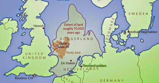
From Press TVOil company divers have discovered 'Britain's Atlantis,' an underwater world which was swallowed by the North Sea between 18,000 and 5,500 BCE. Working with University of St. Andrews science teams, divers found remains of a huge area of land that stretched from Scotland to Denmark and slowly submerged by water.
The 'drowned world' is said to have been the 'real heartland' of Europe, housing tens of thousands of people in an area that stretched from Northern Scotland across to Denmark and down the English Channel as far as the Channel Islands.
Once roamed by mammoths, Doggerland was hit by ‘a devastating tsunami', the researchers say.
“The name was coined for Dogger Bank, but it applies to any of several periods when the North Sea was land,” said Richard Bates of the University of St. Andrews.
“Around 20,000 years ago, there was a 'maximum' - although part of this area would have been covered with ice. When the ice melted, more land was revealed - but the sea level also rose.
“Through a lot of new data from oil and gas companies, we’re able to give form to the landscape - and make sense of the mammoths found out there, and the reindeer. We’re able to understand the types of people who were there.
“People seem to think rising sea levels are a new thing - but it’s a cycle of Earht history that has happened many many times.” Bones found by North Sea fishermen had prompted speculations about the existence of the lost land, but the there were no clues as to how it looked like.
“We have now been able to model its flora and fauna, build up a picture of the ancient people that lived there and begin to understand some of the dramatic events that subsequently changed the land, including the sea rising and a devastating tsunami,” Bates explained.
The St. Andrews, Dundee and Aberdeen universities have now displayed the results of their 15-year-project on the lost land in an exhibition in London. The show will display artifacts recovered from the seabed at the Royal Society Summer Science Exhibition until July 8.
Visitors can see an interactive video showing them how the land might have looked with hills and valleys, large swamps and lakes with major rivers dissecting a convoluted coastline.“There is actually very little evidence left because much of it has eroded underwater; it's like trying to find just part of a needle within a haystack,” said Dr. Bates.
“What we have found though is a remarkable amount of evidence and we are now able to pinpoint the best places to find preserved signs of life.”
-
19th century shipwreck becomes time capsule
- On 10/07/2012
- In Parks & Protected Sites

From SCI NewsAccording to the University of Western Australia (UWA), the Clarence sank in five meters of water and was declared a protected zone in 1985, prohibiting access by divers and anglers.
The site remained popular with local anglers whose anchors and fishing equipment had been damaging the site for decades.
“Constructed of native timbers in New South Wales in 1841, Clarence is one of the best examples of small early colonial-built vessels,” said Prof Peter Veth of UWA, who led the conservation and reburial of the wreck.
The Clarence ran aground on a sand bank in Port Philip Bay in 1850 while transporting 132 sheep from Melbourne to Hobart.
It had anchored in Coles Channel for the night, when the cable broke after a southwest to south southwest wind blew up. The sheep on board were rescued by Geelong residents.
Thanks to the Clarence having a ballast of pipe clay, rather than the usual rocks and stones, some portions of the wreck and the artifacts buried by the clay – including leather patches for valves of pumps, lengths of rope and the bases and staves of oak barrels – have remained well-preserved in the oxygen-free environment it provided.
However, other parts of the wreck have been destroyed by anchor damage, loss of sea grass and scouring. This appears to have become critical in the last 25 years.
Unlike renowned historically significant wrecks such as the Batavia which sank off the Abrolhos Islands in 1629 and the Mary Rose, which sank off the English coast in 1545 which were recovered in full, the Clarence and its artifact assemblages were studied both in situ and in laboratories located on a jack-up barge over the site.