An Oxford-educated researcher is investigating whether Spanish sailors visited New Zealand 116 years before Abel Tasman. Historians generally accept that Tasman, a Dutchman, first sighted the Southern Alps on December 13, 1642.
But Qatar-based researcher Winston Cowie, who spent part of his childhood in Dargaville, is investigating whether the Spanish visited New Zealand as early as the start of the 16th century.
A sighting of a caravel wreck near Aranga on Northland's west coast by Dargaville's shipwreck explorer Noel Hilliam 25 years ago was the catalyst for Mr Cowie's project. Sketches suggested the caravel is the San Lesmes, which disappeared in the Pacific in 1526.
Mr Hilliam says 22 of the 53 crew listed on the 80-tonne caravel came from a Spanish town called Aranga - the same as the Northland area close to the wreck. Mr Hilliam said in June this year Mr Cowie had spent a month in the northwest Spanish town where the main street was called "Rua Tui" - a Maori name.
Mr Cowie found what he believes are two ancient pohutakawa trees at La Coruna, not far from Aranga. Mr Hilliam says that in June next year, a Lincoln University scientist, Dr Jonathan Palmer, will take a core samples to determine the age of the Spanish trees.
Further speculation of the Spanish visitors arises from a number of local Maori surnames that also have Spanish derivatives.
Indigenous communities in Bolivia have objected to Colombia’s plans to recover the remains of an 18th-century galleon believed to be carrying gold, silver and emeralds worth billions, calling on Spain and Unesco to step in and halt the project.
Colombia hopes to begin recovering artefacts from the wreck of the San José in the coming months but the Caranga, Chicha and Killaka peoples in Bolivia propose that the galleon and its contents should be considered “common and shared patrimony”.
A substantial part of the treasure onboard the San José is believed to have been mined by the forced labour of Indigenous peoples in Bolivia, so Colombia’s plans to lift the remains without consulting their descendants would violate international law, the communities said in a letter to Unesco this week.
“Not having our consent, our participation and without taking into account how it will impact the present and future of our communities is irresponsible and contrary to justice,” they wrote.
“We do not have the right to forget, and nor do Spain or any of the American republics … have the right to erase or change our memory.”
The San José was carrying an immense bounty of gold, silver and emeralds from Latin America back to Spain in 1708 when it was sunk by a British fleet off the coast of Cartagena.
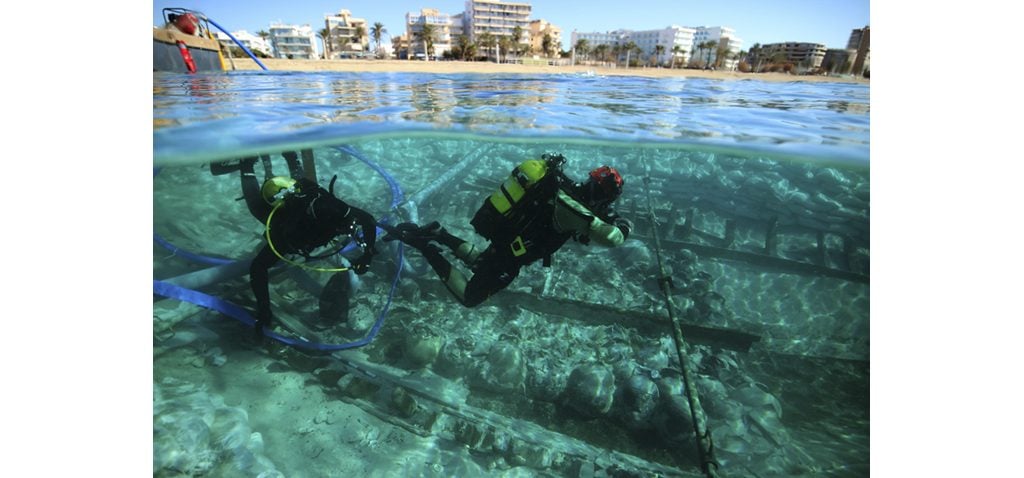
Treasure has been uncovered from a shipwreck dating back to the Roman-era, which was recovered after 17 centuries on the ocean floor.
The trading ship, which was carrying cargos of oil, wine, and fish sauces, was recovered near a tourist beach on the Spanish Mediterranean island of Mallorca in 2019.
Now, archaeologists have recovered 300 amphorae, a form of ancient ceramic jar or vase, decorated with more than 100 painted inscriptions, alongside coins and shoes from the wreck dating from the 4th century.
Previous research suggested that the ship, known as the Ses Fontanelles, originated near the Spanish port of Cartagena.
Analysis from archaeologists has theorised that the vessel was likely heading for modern-day Italy.
During the summer of 2019, a storm hit off the coast of Mallorca’s Ca’n Pastilla beach. The churning waters jostled free the wreckage of a Roman merchant vessel Ses Fontanelles, lost to the world since it sank around the middle of the 4th century C.E.
In the years since, the ancient wreck has been the subject of extensive study as part of a collaboration between the universities of Barcelona, Cádiz, and the Balearic Islands known as Consell de Mallorca. Together, these institutions have undertaken a three-year project dubbed Arqueomallornauta (2021-2023), to take stock of underwater discoveries.
The results, the Consell de Mallorca researchers say, are “frankly exceptional.”
Some 300 amphorae have been unearthed from the cargo holdings. While some are in pieces, many are in remarkably pristine condition. Scientists say the ancient containers were used to transport both fermented fish sauces as well as oil and wines that would’ve been used to preserve fruit.
The amphorae are decorated with painted inscriptions called tituli picti - in fact, 100 painted labels in total were discovered among the wreckage, making it the largest collection of tituli picti in Spain. These provide insight into the crew’s life onboard, as well as into what shipping and trade was like during the 4th century C.E. in the Mediterranean.
A video posted by the University of the Balearic Islands featuring Enrique García, professor of art history and theory, gives a sense of the riches of the site.
Bill Day has spent 35 years and millions of dollars trying to find one of the world’s most famous shipwrecks – the gold-laden General Grant.
The ship struck the Auckland Islands in 1866 and has attracted pirates, treasure hunters and adventurers ever since. Next week, Day leaves from Bluff on his fifth, and final, expedition to discover the wreck. Mike White meets the man who might finally solve the riddle of the General Grant’s gold.
It was a rare and welcome thing – a calm day in the Auckland Islands, a place notorious for being the storm-slashed graveyard of ships and sailors.
It was January 1986 and Bill Day had just slithered back on board an inflatable boat after a fruitless dive trying to find the most famous of these wrecks, the General Grant. He perched on the boat’s edge, admiring the cove they were in, a waterfall tumbling off one edge, a neat archway piercing a peninsula.
“Isn’t it a pity wrecks don’t go down in places like this,” he lamented to the boatman.
Minutes later, fellow diver Willie Bullock broke the surface clutching a lead weight old ships used to measure the water’s depth. “There’s a bit of s..t down there,” Bullock spluttered.
Day couldn’t believe his ears or luck – an unknown wreck in a beautiful location, which fitted the description of where the General Grant sank with a fortune in gold. He flicked on his mask and fins, and rolled back into the water.
As the bubbles cleared in front of his mask and he dived towards the seabed, Day was already thinking that maybe they’d finally solved the mystery of the General Grant that had confounded and eluded so many, for so many years.
The General Grant had set sail from Melbourne in May 1866, bound for England with 83 crew and passengers on board. It was a 180’ square-rigged sailing ship, built in Maine two years before, and carrying a cargo including wool and skins. But it also carried 2576 ounces (73kg) of gold, probably in bars and sovereigns.
And on top of that, many of the passengers were miners returning home with small fortunes in gold, scraped and scrabbled from the unforgiving earth of Victoria’s goldfields. On the evening of May 13, 10 days after setting sail, the General Grant’s captain was alarmed to hear a cry from the masthead that land had been sighted dead ahead, and altered course.
El 5 de octubre de 1804, a 30 millas náuticas del cabo de Santa María de Portugal, en actuales aguas internacionales, la Marina Real británica hundió a cañonazos la fragata Nuestra Señora de las Mercedes.
El inesperado ataque se llevó a cabo violando el Tratado de Paz de Amiens —suscrito entre Francia, España y Reino Unido— de 1802. Murieron 275 tripulantes, mientras un enorme cargamento de oro, plata y cobre se hundía en el mar a unos 1.130 metros de profundidad.
En 2007, la compañía cazatesoros Odyssey Marine Exploration expolió 600.000 monedas de la carga, aunque España terminó recuperándolas en los tribunales estadounidenses. Sin embargo, como revelan las actas del congreso internacional Archaeology: Just Add Water, celebrado en Varsovia en 2019, ahora hechas públicas, los expoliadores solo se centraron en las monedas y abandonaron todo lo demás.
Dejaron intacto el segundo tesoro de la Mercedes. Centenares de sus piezas ya han vuelto a España, están siendo restauradas y se expondrán en noviembre. Nunca se había hecho una excavación a tal profundidad.
En 2014 el Museo Nacional de Arqueología Subacuática, ARQUA, (Cartagena), dependiente del Ministerio de Cultura, inició un proyecto para que España excavase científicamente el pecio. Se trataba de un reto nunca acometido por ningún país.
Los dos o tres casos anteriores en los que se había bajado por debajo de los 500 metros se habían limitado a filmar y fotografiar. El plan del museo planteaba que era perfectamente posible hacerlo si se aunaban esfuerzos.
Se invitó al el Instituto Español de Oceanografía (IEO) y se cursó también invitación a la Armada como institución observadora. Aceptó.
En verano de 2015, zarpó de Cartagena la primera expedición conjunta a bordo del buque oceanográfico Ángeles Alvariño, del IEO. Al llegar a la vertical del pecio, la primera inmersión del ROV (siglas en inglés de vehículo operado remotamente, un complejo equipo submarino teledirigido), localizó exactamente el corazón de la nave.
Pero las pantallas de los ordenadores señalaban que los restos estaban muy dispersos debido a la explosión de 1804 y a las técnicas destructivas de Odissey. Se tomaron miles de fotografías y vídeos. La campaña se repitió en las de los veranos de 2016 y 2017.
A esta última se sumó el Centro de Investigaciones Científicas (CSIC), que aportó el buque Sarmiento de Gamboa. Los minisubmarinos detectaron esta vez “un tesoro más importante: miles de objetos enterrados bajo el fondo marino que muestran, en parte, cómo era la vida a principios del siglo XIX: de cañones de bronce a vajillas de oro y plata”. “Su valor científico y museístico”, como señala el informe del director del ARQUA y del proyecto, Iván Negueruela, “es incuestionable”.
El estudio recién publicado por la Universidad de Varsovia titulado The Mercedes 2015–2017 Project: Exploration and Excavation of the Wreck Nuestra Señora de las Mercedes (1.138 m depth) (Proyecto Mercedes 2015-2017.
Exploración del pecio de Nuestra Señora de las Mercedes (1.138 metros de profundidad) señala que el objetivo de las tres campañas fue definir “la extensión del yacimiento, documentar las condiciones en que quedó este tras el saqueo, realizar un mapa arqueológico de los materiales que permanecen bajo el lecho marino y la extracción de algunos de los materiales detectados”.