Marine Sciences
Marine Laboratories, Techniques and Research News
-
3D sonar uncovers skeleton of Civil War battleship
- On 25/01/2013
- In Marine Sciences
- 0 comments

By Flora Graham - New Scientist
Looking like the weathered skeleton of some ancient dinosaur, the rusting remains of an American Civil War battleship have been imaged in their underwater grave by 3D sonar.
The USS Hatteras sank during battle with the CSS Alabama in 1863, coming to rest in 17 metres of water in the Gulf of Mexico, 30 kilometres off the coast of Galveston, Texas.
One hundred and fifty years later, the bones of the iron-hulled paddle-wheel steamship have been mapped by the US National Oceanic and Atmospheric Administration (NOAA).
NOAA made the scans after local underwater photographer Jesse Cancelmo noticed that recent storms had shifted some of the sediment and sand that covered the wreck.
The main image above shows the curved tooth-like outline of the stern on the right.
The paddle-wheel shaft stretches from the top to the bottom of the picture, where the remains of the port paddle wheel lie crumpled like the bones of a skeletal hand.
More than half of the ship still lies beneath the seabed."
Most shipwreck survey maps are two-dimensional and based on observations made by sight, photographs or by feeling around in murky water while stretching a measuring tape," said James Delgado of NOAA's Office of National Marine Sanctuaries.
-
The future of deep-sea exploration
- On 20/01/2013
- In Marine Sciences
- 0 comments
By Andrew David Thaler - Southern Fried Science
Newsweek, in is new and impressive digital format, released a series of articles this week on deep-sea exploration, the challenges of human occupied and remotely-operated vehicles, and the decline in funding for ocean science, particularly in the deep sea.
The main article, The Last Dive ? Funding for Human Expeditions in the Ocean May Have Run Aground, is a deep, detailed look at the state of deep-sea science, seen through the eyes of Dr. Sylvia Earle and Dr. Robert Ballard, two giants in the ocean community.
The follow-up, James Cameron Responds to Robert Ballard on Deep-Sea Exploration, provides insight into the mind of James Cameron, who last year successfully dove the Challenger Deep in his own deep-sea submersible. Both the articles continue to perpetrate the canard that there is a deep chasm between the human-occupied submersible (HOV) and remotely-operated vehicle (ROV) communities.
The reality is that deep-sea scientists use a variety of tools, from mechanical samplers to autonomous robots, to study and understand the deep.
The choice comes down to which tool is most efficient, least expensive, and currently available. Absent a sea change, ROV’s will continue to be the workhorses of deep-sea research. And that is a good thing.
I sang the praise of my robot underlings the last time this debate breached the public consciousness.
I also discussed why basic deep-sea research and training highly skilled ROV pilots is a matter of national security. Ballard and Earle have been on opposite sides of this divide for a long time, with Earle pushing for a greater human presence in the ocean and Ballard supporting the continued expansion of telepresence technologies that allow scientist and the public to interact with deep-sea assets from the comfort of facilities like the Inner Space Center in Rhode Island.
Cameron, whose most successful movie to date is a essentially a meditation on how awesome it is to pilot a really sophisticated ROV, takes the stance that young minds cannot be inspired by remotely-operated exploration, that someone must be there to “experience it first hand and return to tell the story”, claiming “the quickest way to get even less interest and engagement is to take human explorers out of the vehicles.”
I categorically reject the implication that people cannot be inspired unless another person is physically there. The Mars Curiosity Rover is proof enough that our robotic brethren are nothing less than extensions of our own senses.
-
High-frequency Side Scan Sonar
- On 01/01/2013
- In Marine Sciences
- 0 comments
From Hydro International
JW Fishers, USA, has added a new high-frequency side scan system to their line.The 1200kHz sonar produces detailed images of even small and soft targets such as old wooden wrecks, areas of scattered debris, or a drowning victim.
The new sonar is available as a single-frequency system or a dual-frequency side scan with two sets of transducers in one towfish.
Putting two sets in one fish provides versatility allowing the operator to switch between frequencies at any time during operation. The lower frequency is capable of scanning long ranges, but with less resolution.
When the 1200kHz was towed over a bicycle that had been disposed of in a waterway (inset), the bike’s frame and wheels were clearly visible, as well as the seat and other features.
The two frequencies available for coupling with the 1200kHz in a dual-frequency system are the 600kHz and the 100kHz.
The 600kHz provides a combination of range and resolution with a maximum scan of 200 feet per side (400 foot swath), yet with the capability of detecting small targets.
The 100kHz has the longest range, up to 2,000 feet per side (4,000 foot swath), making it ideal for scanning large areas when searching for big targets such as downed aircraft or sunken ships.
-
China to build first archaeological vessel
- On 25/10/2012
- In Marine Sciences
- 0 comments
China plans to build its first vessel capable of retrieving archaeological findings from the sea by the end of 2013, a major step to strengthening the underwater search abilities of Chinese archaeologists who currently rely on rented shipping boats.
The 4.8-metre wide and 56-metre long boat, to be powered by an integrated full electric propulsion system, will "basically" meet China's underwater archaeological needs, according to a statement released by the State Administration of Cultural Heritage (SACH) on Wednesday.
With a displacement of 860 tonnes, the vessel will be used in China's coastal areas and could sail as far as waters off the Xisha Islands, or the Paracel Islands, in the South China Sea, if sea conditions are good, it said.
Archaeologists will be able to use the ship to detect, locate, map, videotape and excavate underwater archaeological findings, according to the SACH.
The vessel is being designed by the 701 research institute of China Shipbuilding Industry Corporation and built by the Changhang Dongfeng shipbuilding corporation in Chongqing.
The news will be a boon for Chinese archeologists who have long struggled with the inconvenience of having to ride fishing boats along China's 18,000 km-long coastline in order to uncover the country's massive quantities of underwater relics.
Many speculators and fishermen have joined this hunt for treasures in the South China sea, a busy sea lane which is said to have at least 122 wrecked ships on its bottom.
Many of the wrecked ships date back to the Tang (618-907) and Song (960-1276) dynasties, when China's trade with foreign countries was thriving.
Many speculators and local fishermen surveying the area have used crude means to retrieve underwater relics, prompting authorities to take action.
The protection of China's underwater relics faces "severe challenges" from rampant looting of underwater relics, the SACH said in the statement, adding that the country needs to improve its talent tool of archaeologists and related facilities. -
Calculating evaporation from the ocean
- On 12/10/2012
- In Marine Sciences
- 0 comments
By Lonny Lippsett - Oceanus
Imagine you turn on the tap in the morning and water pummels out and spills over your sink.
Later you go out to your garden, but water trickles feebly out of the hose.
The water pump in your house is definitely not working the way it used to. Scientists say something like that is probably happening in our planetary home.
Climate change is gunning the motor of Earth’s water pump, driving more rainfall to already wet areas and less to drier regions.
To get a handle on how things will change, it would sure help if we could get a handle on how the motor is driving more moisture to the atmosphere.
But figuring out how and why water molecules move between air and ocean, at present at least, is a formidable challenge for scientists.
“It’s the boundary between two turbulent fluids, the ocean and atmosphere; each is it’s own thing, basically chaotic and hard to calculate,” said Carol Anne Clayson, an oceanographer at Woods Hole Oceanographic Institution.
“Then the two are coupled: If something changes the sea surface temperature, for example, the atmosphere responds to it, and every atmospheric response changes the sea surface temperature,” she said.
“We don’t have the computational power to simulate in a model all the physics that goes on—even if the interface between them were flat and never-changing.”
Which it is most definitely isn’t. The air-sea interface “is typically the most turbulent part of the ocean,” Clayson said.
A dizzying mix of interrelated factors—waves, winds, water temperature and salinity, bubbles and spray, solar radiation, and others—each add a layer of complexity that occurs over wide ranges of time (seconds to seasons) and space (millimeters to miles).
-
Sunken Civil War ship shifts into view
- On 13/09/2012
- In Marine Sciences
- 0 comments
By Michael Graczyk - The Herald TribuneThe world will soon get its first good look at the wreckage of the only U.S. Navy ship sunk in combat in the Gulf of Mexico during the Civil War, thanks to sophisticated 3-D sonar images that divers have been collecting this week in the Gulf's murky depths.
The USS Hatteras, an iron-hulled 210-foot ship that sank about 20 miles off the coast of Galveston, Texas, in January 1863, has sat mostly undisturbed and unnoticed since its wreckage was found in the early 1970s.
But recent storm-caused shifts in the seabed where the Hatteras rests 57 feet below the surface have exposed more of it to inspection, and researchers are rushing to get as complete an image of the ship as possible before the sand and silt shifts back.
"You can mark Gettysburg or Manassas, (but) how do you mark a battlefield in the sea ?" said Jim Delgado, the director of maritime heritage for the National Oceanic and Atmospheric Administration's Office of National Marine Sanctuaries, and the person overseeing the project.
On Monday, a team of archaeologists and technicians began two days of scanning the wreckage using a sonar imaging technology that hadn't been used yet at sea, Delgado said.
On Monday aboard the research vessel, Manta, researcher Christopher Horrell gleefully pored over computer images of the Hatteras' stern and paddlewheels that had just been transmitted from the sea floor.
-
Capturing history while updating charts
- On 26/07/2012
- In Marine Sciences
- 0 comments
From Hydro International
USA Coast Survey’s Navigation Response Team 4 is conducting a year-long survey of the sea floor in the Port of Houston and Galveston Bay navigational areas, re-measuring ocean depths and searching for dangers to navigation.In collaboration with NOAA’s Flower Garden Banks National Marine Sanctuary and the Texas Historical Commission’s Marine Archeology Division, the navigation response team has re-mapped the location of two historically significant wrecks, one of them being the City of Waco steamship.
The steamship City of Waco is one of the historical wrecks that Forfinski’s crew was asked to survey.
The steamship burst into flames and sank on 8 November 1875, and 56 people died.
The sunken ship was ordered to be demolished in 1900, to protect navigation in the area, and the wreck was discovered seven years ago.
Nick Forfinkski, the navigation response team’s leader said that with the often-shifting sediment around that area, there are periods of covering and uncovering, so archeologists like to periodically map historically significant wrecks to see what’s changed.As the team was around surveying for maritime commerce, they were able to obtain up-to-date images of the wrecks.
Forfinkski’s team captured some fascinating images of the City of Waco, created from data they gathered during last week’s hydrographic survey as the multi-beam image with this article, obtained from NOAA.The echosounder used is a Kongsberg EM3002, grid resolution 0.25m and vertical exaggeration 2.5x.
-
Symbiosis in the deep sea
- On 23/07/2012
- In Marine Sciences
- 0 comments

From Oceanus
Scientists discover how bacteria living with shrimp make a living.Mobs of pale shrimp clamber over each other, jockeying for position in the swirling flow of black-smoker vents on the seafloor where ultra-hot fluids from Earth’s interior meet cold seawater.
The shrimp, Rimicaris exoculata, are not the only animals that live near these vents on the Mid-Atlantic Ridge, the volcanic seafloor mountain range that bisects the ocean basin.
But they are by far the most abundant, with population densities reaching 3,000 individuals per square meter.
Though numerous and known to science since 1986, how they make their living is still a mystery.
At first, scientists thought they grazed on bacteria that grow on the chimney-like walls of the vents, which spew dark, chemical-rich fluids into the ocean.
Then, in the 1990s, a novel kind of bacterium was found living in the shrimps’ gill chambers.
That finding raised the possibility that Rimicaris relies on symbiotic relationships with bacteria, which, in turn, need chemicals in the vent fluids to live.
But figuring out how two organisms interact requires more detailed knowledge than just seeing them together. What kinds of bacteria are present with the shrimp ?
What, if anything, do the bacteria and the shrimp provide to each other ? How do they do it ?
-
A mini sub made from cheap parts could change underwater exploration
- On 03/06/2012
- In Marine Sciences
- 0 comments

Photo Brian Lam
By Brian Lam - The New York Times Bits
This month, NASA engineer Eric Stackpole hiked to a spot in Trinity County, east of California’s rough Bigfoot country.
Nestled at the base of a hill of loose rock, peppered by red and purple wildflowers, is Hall City Cave.
For part of the winter the cave is infested with large spiders, but is mostly flooded year-round. Locals whisper the cave’s deep pools hold a cache of stolen gold, but Mr. Stackpole isn’t here to look for treasure.
He had, under his arm, what might appear to be a clunky toy blue submarine about the size of a lunchbox.
The machine is the latest prototype of the OpenROV–an open-source, remotely operated vehicle that could map the cave in 3D using software from Autodesk and collect water in places too tight for a diver to go.
It could change the future of ocean exploration. For now, it is exploring caves because it can only go down 100 meters.
But it holds promise because it is cheap, links to a laptop, and is available to a large number of researchers for experimentation.
Indeed, the OpenROV team hopes to start taking orders for OpenROV kits on the crowd sourced project site, Kickstarter.
Going for $750, the kits include laser cut plastic parts and all the electronics necessary to build an OpenROV.
(Users will have to bring their own laptops to view the onboard video feed and control the machine. They’ll also have to supply their own C-cell batteries which power the sub.)
The subs are expected to be available by the end of summer. OpenROV is nothing like James Cameron’s submarine that took him to the bottom of the ocean in March. Mr. Cameron’s Deepsea Challenger was fitted with 3-D cameras that could withstand 16,000 pounds of pressure per square inch, and was shaped like a bomb so it could swiftly plunge into the depths.
Nor is OpenROV like the famous submarine, Alvin, that explored the Titanic in 1986, with its titanium cockpit and its operating cost of around $55,000 a day. Mr. Stackpole can’t afford exotic alloys or custom technology for his little sub.
-
First-aid kit in shipwreck reveals millennia-old practices
- On 09/07/2011
- In Marine Sciences
- 0 comments
By Nick Squires - NZ Herald
Institute first-aid kit found on a 2000-year-old shipwreck has provided a remarkable insight into the medicines concocted by ancient physicians to cure sailors of dysentery and other ailments.
Medicines found inside a wooden chest included pills made of ground-up vegetables, herbs and plants such as celery, onions, carrots, cabbage, alfalfa and chestnuts - all ingredients referred to in classical medical texts.
The tablets, which have miraculously survived being under water for more than two millennia, also contain extracts of parsley, nasturtium, radish, yarrow and hibiscus.
They were found in 136 tin-lined wooden vials on a 15m-long trading ship which was wrecked about 130BC off the coast of Tuscany.
Scientists believe they would have been used to treat gastrointestinal complaints suffered by sailors such as dysentery and diarrhoea.
"It's a spectacular find. They were very well sealed," said Dr Alain Touwaide, from the Smithsonian Conservation Biology Institute in Washington DC.
"The plants and vegetables were probably crushed with a mortar and pestle - we could still see the fibres in the tablets. They also contained clay, which even today is used to treat gastrointestinal problems."
The pills are the oldest-known archaeological remains of ancient pharmaceuticals.
They would have been taken with a mouthful of wine or water, or may have been dissolved and smeared on skin to treat inflammation and cuts. -
Underwater coring technique allows archaeologists to go deeper than ever before
- On 06/06/2011
- In Marine Sciences
- 0 comments
By Randy Boswell - Vancouver Sun
A team of Canadian scientists has used geology-style drill cores from an Ontario lake bottom to gather evidence of tool-making and perhaps even duck-hunting by ancient aboriginals about 10,000 years ago — the first discovery of its kind in North America, and one that could point the way to further breakthroughs in underwater archeology around the world.
Led by researcher Lisa Sonnenburg of McMaster University in Hamilton, Ont., the team took sediment samples from a shallow section of Rice Lake — a popular summer vacation spot northeast of Toronto — where prehistoric First Nations were known to have camped soon after the glaciers retreated at the end of the last ice age.
The scientists found more than 150 tiny flakes of quartz in the lake’s murky depths — strong evidence that an ancient shoreline, submerged long ago, was used by some of Canada’s earliest inhabitants as a site for manufacturing spear points, scrapers and other tools for fishing and hunting.
The discovery not only sheds new light on the activities of those prehistoric people, but also pioneers a novel method of detecting the presence of ancient aboriginals in what are now drowned landscapes — a technique with huge research potential in Canada’s Great Lakes region and many other places around the world where suspected settlement sites have became inundated over time.
The team’s analysis of telltale markings of human activity on the quartz fragments — known as “microdebitage” among archeologists — shows that the technique “offers a reliable quantitative method for narrowing search areas and for identifying new areas of underwater archeological potential,” the researchers conclude in a study published in the July issue of the journal Geology.
Sonnenburg told Postmedia News that the team targeted “what we thought was an old shoreline” and that the drill cores proved that’s “exactly what it was.”
She recalled “staring down the barrel of a microscope” for a long time before beginning to see quartz chips at a consistent layer of sediment, about two metres deep, that suggested the ancient occupation of the site. -
State-of-art chamber is a lifesaver for divers
- On 04/06/2011
- In Marine Sciences
- 1 comments
By Ciaran Tierney - Galway City Tribune
It is as close as you can get to entering a spaceship, or a submarine, without leaving dry land in the West of Ireland, and it has helped save the lives of scuba divers.And yet many people might not be aware that the Republic’s national medical hyperbaric chamber, which opened late last year at a cost of €1 million, is located at University Hospital Galway.
No scuba diver wants to have to use it, and yet each and every one of them should be delighted that it is there. While the popularity of deep sea diving has increased remarkably over the past decade, the chamber ensures that divers no longer need to be airlifted to Plymouth or Portsmouth in the UK for top class medical treatment.
It is operated mainly by a team of committed, highly trained volunteers who are on call to help out medical staff 24 hours a day, seven days a week, in case any diver gets into difficulties in Irish waters.Whether he or she needs to be airlifted from Co Kerry or take an ambulance from Carraroe, a committed team of three will be on hand to administer the treatment once the alarm is raised.
Decompression sickness or ‘the bends’, caused by breathing excess nitrogen under pressure, is a hazard faced by divers who surface too quickly or are forced to divert from their dive plans. Hyperbaric oxygen therapy is the only cure and UHG is the only hospital in the country to provide it.
Symptoms of ‘the bends’ include joint pains along the arms or legs, severe itching, numbness, staggering due to poor balance, and acute pain. It is important to seek medical treatment as soon as possible if a diver experiences difficulties after a dive.
UHG was the first and only hospital in the country to get a hyperbaric chamber, pioneered by the late Dr Peter O’Beirn, who was also a keen diving enthusiast, back in 1976. A diver would be strapped into the old ten foot long capsule for treatment, but the unit became obsolete and had to be shut down a few years ago.
While the old chamber might have seemed uncomfortable, it did the job for any diver who got into difficulties through the 1970s, ‘80s, and ‘90s.But it was unrecognizable compared to the sparkling new facility at UHG which has seating for ten patients, audio and visual links, and even a DVD player if a patient wishes to watch a film during treatment which can last for up to six hours.
At the moment, the chamber is only used for emergency cases of decompression illness or carbon monoxide poisoning. But, were the funding to become available, it could have a host of other uses, tackling traumatic brain injury, stroke, air embolism, gas gangrene, and nervous system problems which can be tackled by allowing a patient to breathe pure oxygen.
-
What makes a 300-year-old pocket watch tick ?
- On 13/10/2010
- In Marine Sciences
- 0 comments
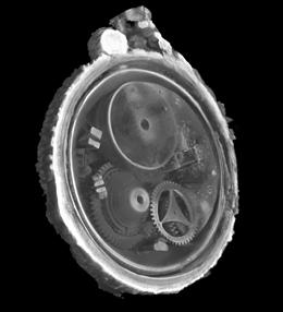 Trustees of NMS
By Jo Marchant - Nature.com
State-of-the-art X-ray scans have revealed the internal mechanisms of a corroded, barnacle-covered pocket watch recovered from a seventeenth-century wreck.The watch looks little more than a lump of rock from the outside, but the scans show that the mechanism inside is beautifully preserved, from delicate cogwheels and Egyptian-style pillars to the maker's inscription.
Researchers from the National Museums Scotland in Edinburgh used the images to construct a three-dimensional virtual reconstruction of the watch's lost workings.
They hope to use the technique to probe the internal structure of other archaeological artefacts, especially those salvaged from underwater sites.The watch and three-dimensional reconstruction are now on display in the Treasured exhibition of the National Museum of Scotland until 2011.
The watch was found on a wreck believed to be the Swan — a small warship that sank off the west coast of Scotland during the English Civil War. She formed part of Oliver Cromwell's forces that attacked the Royalist stronghold of Duart Castle in Mull, UK, but succumbed to a violent gale on 13 September 1653.
A naval diver discovered the wreck in the 1970s, and it was excavated in the 1990s. Salvaged artefacts including the pocket watch, a hoard of silver coins, cast iron guns and an ornate sword hilt were taken to the National Museum of Scotland. -
Ship researchers get stuck into tar and pitch
- On 09/10/2010
- In Marine Sciences
- 0 comments
By Robin Turner - Western Mail
Welsh researchers examining a historic Newport ship are to look in detail at how expert 15th century ship-builders kept vessels watertight.
European funding will allow research on the exceptionally effective tars and pitches used to seal and repair the hulls of ships more than 500 years ago.The remains of the medieval vessel were found on the west bank of the River Usk, which runs through Newport’s city centre, during the building of the Riverfront Arts Centre.
The ship was originally about 80ft long and its watertight structure made it quite capable of continental voyages.
Artefacts found in the ship suggest it was trading with Portugal in the 15th century. There are also theories that the ship might have been built there. Tree-age dating has given a likely felling date of 1465 and 1466 for some of the timbers used in both its construction and its repair.
Maritime archaeologist Nigel Nayling has overseen the research and conservation of the ship since its discovery in 2002. He is now overseeing the European funded research into tars and pitches used in the ship which involves scientists from Cardiff University, the British Museum and the University of Wales Trinity Saint David.
Mr Nayling, of the University of Wales Trinity Saint David said: “Tars and pitches are black sticky substances produced by heating wood.
“They have an ancient history of use as all-purpose waterproofing agents and adhesives. In medieval times their role in ship building and maintenance led them to acquire vital strat- egic and political importance for the developing European seafaring economies and naval fleets.”
The project, funded by the Marie Curie Intra-European Fellowship scheme, will bring French expert Dr Pauline Burger to the UK for two years. She will use analytical chemistry techniques and experimental modelling to work out what kinds of tar were used on the ship, how they were made and where they came from.
She will compare the tars and pitches on the Newport ship with those from other shipwrecks and from the collections of the British Museum where tars and pitches occur on objects as varied as ancient Greek amphorae, Egyptian sarcophagi and Iron Age harness fittings. -
New images may yield Viking ships
- On 07/10/2010
- In Marine Sciences
- 0 comments
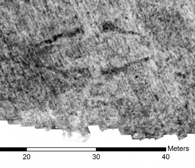 LBI ArchPro / NIKU
From News in English
Archaeologists think they have found two more Viking ships buried in Vestfold County south of Oslo. The biggest may be 25 metres long, larger than any found so far.
Road construction near the old Viking trading center at Kaupang has led to the discovery of two large ship silhouettes on ground radar pictures.The pictures have been made possible through a venture involving the Norwegian Institute for Cultural Heritage Research (Norsk institutt for kulturminneforskning, NIKU) and the Ludwig Boltzmann Institute for Archeological Prospection and Virtual Archeology.
They portray some “exciting” images with the help of high tech methods including satellites, laser scanning, magnetometers and georadar, according to NIKU officials.The methods can avoid or minimize destructive excavations by allowing archaeologists to register what the Norwegians call kulturminner (cultural antiquities) under the surface with a high degree of precision.
The images of Viking ships, along with several burial mounds, could be the biggest discoveries of their kind for more than a century, and some call them potentially “sensational” while officials urge restraint.
Even though the data so far is startling, the head of the Directorate for Cultural Heritage in Norway, Jørn Holme, told Norwegian Broadcasting (NRK) that people should not expect too much at this stage. -
ECU students explore, document shipwrecks
- On 05/10/2010
- In Marine Sciences
- 0 comments
By Ginger Livingston - The Daily Reflector
Efforts to document two shipwrecks in South Carolina's Cooper River by East Carolina University students and researchers ended up with more questions than answers about who used the boats.
Shards of Native American pottery discovered in wreckage at a site called the Pimlico shipwreck have researchers asking if it's evidence that the ship's owners possessed Native Americans slaves, if there was trade between Native Americans and individuals who worked on the ship or if perhaps it's debris that washed in the wreckage.
Discovering such a mystery is what drives students and researchers in ECU's Maritime Studies program.
Founded in 1981, the Maritime Studies program, part of the university's Department of History, offers a master's degree in maritime history and nautical archaeology. ECU's program was the second in the nation and today is only one of four programs in the nation.
“We have an emphasis on field work,” said Lynn Harris, assistant professor of Maritime Studies. Harris came to ECU from South Africa and was an early student of the program.
Teaching students the practical skills needed to work underwater sites routinely places students in the murky rivers and sounds of the Carolinas, the turbulent waters of the Atlantic and even Sweden and Namibia to study shipwrecks.
Students must participate in two field projects before earning their degree.
This requirement sent 20 students and professors to Charleston, S.C., for three weeks last month to study two plantation boats on display at the Charleston Museum and Middleton Place, a historic plantation. They also worked on the Pimlico and another shipwreck at Strawberry Landing, also along the Cooper River.
Because of tidal influences, dives on the two wrecks had to be split with time spent on land recording information about the plantation boats, which were called the Bessie and the Accommodate.
Both were built in 1855 and designed to transport people, crops and other materials around South Carolina's interior waterways.
The Bessie and Accommodate fascinated second-year student Nathaniel Howe, who previously worked on a project restoring a Swedish warship. The exterior hulls resembled Native American dugouts because each was shaped from a single log. However, the two boats' builders shaped the exterior to resemble the hull of a European boat and lined the interior with planks. It was designed to be rowed or sailed, Howe said. While recording its dimensions, the students saw how one boat's user relocated the mast.
“It's amazing how much history is in this structure,” he said.
The students used a piece of equipment called a total station to record a three-dimensional image of a point on the boat. The points are combined eventually to make a three-dimensional model of the boat.
-
Mother Earth could have parted sea for Moses' escape
- On 22/09/2010
- In Marine Sciences
- 0 comments
By Brett Israel - msnbc.msn.com
Mother Earth could have parted the Red Sea, hatching the great escape described in the biblical book of Exodus, a new study finds.
A strong east wind, blowing overnight, could have swept water off a bend where an ancient river is believed to have merged with a coastal lagoon along the Mediterranean Sea, said study team member Carl Drews of the National Center for Atmospheric Research. While archaeologists and Egyptologists have found little evidence that any events described in Exodus actually happened, the study outlines a perfect storm that could have led to the 3,000-year-old escape.
"People have always been fascinated by this Exodus story, wondering if it comes from historical facts," Drews said. "What this study shows is that the description of the waters parting indeed has a basis in physical laws."
Drew and his colleagues used models that showed that a wind of 63 mph, lasting for 12 hours, would have pushed back waters estimated to be 6 feet deep. This would have exposed mud flats for four hours, creating a dry passage about 2 to 2.5 miles long and 3 miles wide.
To match the account in the Bible, the water would have to be pushed back into both the lake and the channel of the river, creating barriers of water on both sides of newly exposed mud flats, which is exactly what the models show could have happened.
As soon as the winds stopped, the waters would come rushing back. Anyone still on the mud flats would be at risk of drowning.
As the Bible story goes, Moses and the fleeing Israelites were trapped between the Pharaoh's advancing chariots and a body of water that has been variously translated as the Red Sea or the Sea of Reeds.In a divine miracle, a mighty east wind blew all night, splitting the waters and leaving a passage of dry land with walls of water on both sides.
The Israelites were able to flee to the other shore. But when the Pharaoh's army attempted to pursue them in the morning, the waters rushed back and drowned the soldiers.
-
Could a sunken WWII tanker leak oil ?
- On 31/08/2010
- In Marine Sciences
- 0 comments

By Pete Hardie - Santa Barbara Independent
Researchers hope to use sonar images of the SS Montebello to determine if the sunken vessel could leak oil.The Montebello Assessment Task Force sent a robotic submersible down to the wreck — which lies seven miles off California’s coast, near Cambria — last week.
The vessel’s tanks are presumed to still contain the three million gallons of Santa Maria crude oil that were loaded before its departure in December 1941.
The SS Montebello lies at a depth of approximately 900 feet. It sunk after being torpedoed by an Imperial Japanese submarine.Kim Fulton-Bennett of the Monterey Bay Aquarium Research Institute (MBARI) said, “When the ship was sunk by the Japanese submarine, you might have expected the oil to leak out, as the whole bow of the ship fell off.”
However, according to Fulton-Bennett, neither the rescued sailors nor their rescuers reported any signs of oil leakage.
The second question, as Fulton-Bennett put it, regards the state of the oil if it does in fact remain in the ship’s tanks. It may be that the oil solidified over time and doesn’t threaten to leak out, but it is difficult to accurately predict whether this is the case.
The Montebello Assessment Task force was commissioned in 2008 by California Assemblymember Sam Blakeslee after he read an article on the sunken ship. The Task Force will work to identify all environmental issues resulting from the wreckage.It includes representatives from MBARI, the Office of Spill Prevention and Response, the U.S. Coast Guard, and Caltrans.
The MBARI’s robotic submersible — commissioned by the Task Force to investigate the wreckage — embarked on a three-day mission and gathered data using three different types of sonar.This allowed researchers to build a full 3-D picture of the shipwreck’s external condition and layout, and of the sea floor’s rock densities.
-
The S.S. World Trade Center sets sail
- On 29/07/2010
- In Marine Sciences
- 0 comments

By David W. Dunlap and Fred R. Conrad - The New York Times
Whatever the antique vessel was, and whenever in the 18th century it arrived on the Lower Manhattan waterfront, one thing can be said almost certainly: Its journey in was easier than its journey out.
The vessel was discovered by workers on July 13, about 20 to 30 feet below street level, during the excavation of a site bounded by West, Washington, Liberty and Cedar Streets.
This area — which had not been disturbed during the construction of the original World Trade Center — will one day house the vehicle ramps leading to the network of roadways, loading areas and parking spaces under the new World Trade Center.
The wood-hulled ship was an object of instant archaeological interest and popular speculation. The Port Authority of New York and New Jersey worked around it as much as possible while keeping the excavation on track.
But the time for salvaging and removing the vessel finally arrived on Monday. Among those on site for the delicate operation were the archaeologists A. Michael Pappalardo, Diane Dallal and Molly McDonald of AKRF, the consulting firm working for the Port Authority; Warren Riess of the Darling Marine Center of the University of Maine, who worked on the last vessel unearthed in Lower Manhattan in 1982; and Nicole Doub, the head conservator of the Maryland Archaeological Conservation Library in St. Leonard, to which the remnants of the ship are bound — piece by piece. -
At Woods Hole, conquering the deep ocean
- On 17/07/2010
- In Marine Sciences
- 0 comments
By Daniel Terdiman - Cnet News
Although crews have managed to shut off--for now, at least--the flood of oil into the Gulf of Mexico, it is virtually certain that ongoing cleanup work will keep the concept of deep-sea science in the public's eye for some time.
That could be good news for the scientists and researchers at the Woods Hole Oceanographic Institution (WHOI) here, one of the world's leading repositories of across-the-board ocean expertise, and the developers of a stunning collection of hardware and software tools designed to probe the countless mysteries of the deep.
I've come here as part of Road Trip 2010, and have been promised a close-up view of Nereus, one of the most exciting developments in underwater research in years.Nereus is a new style tool: a hybrid remotely-operated vehicle, meaning that it is the rare beast that can be used for pre-programmed, untethered research missions, or those in which it is controlled from the surface via a very thin, fiber cable that can reach 25 miles.
This is one of the only vessels on the planet capable of reaching the oceans' deepest locations, and it can do so while sending back high-fidelity data that could vastly broaden our understanding of what goes on below.Yet, despite the promise of Nereus and the other vehicles in the WHOI fleet, as well as that of other institutions, there is little doubt that deep-ocean research has, until recently, barely registered on the national consciousness.
After all, just before the recent celebration of the 50th anniversary of the first--and only--manned mission to the bottom of the Mariana Trench, the deepest spot on Earth, at 35,800 feet, Don Walsh, one of the two men who had taken that trip, told CNET News, "We were happy to be the first, but we didn't expect to be the last."
To talk to me about Nereus, I've come to see Andy Bowen, the director of WHOI's national deep submergence facility.
Until now, Bowen said, most of the world's deep ocean exploration energies has gone into probing at 6,000 meters below the surface or above.That's because, he said, 98 percent of the world's seafloor is above that level. The remaining 2 percent has largely been inaccessible. "We tend to look in the the easy places first and the hard places last," he said.
The history of deep-sea submersibles has been about two kinds of vessels: Autonomous underwater vehicles (AUVs), which are designed to explore wide areas of the deep, mapping as they go and providing scientists with broad looks at the ocean floor; and remotely-operated vehicles (ROVs), which are tethered to a surface ship and which transmit data--photos, video and more--back over some kind of cable.
But Bowen explained that as scientists probe deeper and deeper, the costs of the exploration has traditionally grown, given the need for more sophisticated, and rugged equipment.
-
Ancient ship replica helps fund Java dig
- On 04/07/2010
- In Marine Sciences
- 0 comments

From The Japan Times
The Indonesian government and a Japanese academic group have recently reconstructed an ancient ship to raise money for an archaeological study on historic ruins in and around Java.
According to the Japan Majapahit Association, the ship has been making port calls in Asian countries since late last month, asking for financial and technical support to excavate the ruins of the Majapahit kingdom, which existed in the area from the 13th to the 16th century.
The ship was built in Madura, part of Indonesia's Java Province, and left there on June 27 for a six-month, 9,000-km journey, before heading back to Jakarta.
It will reach Japan around the middle of July, making its first stop in Kudaka Island, Okinawa Prefecture. The island served as a trading post of the Ryukyu kingdom, which used to govern Okinawa.
The ship will then sail to Naha. The crew will pay Okinawa Gov. Hirokazu Nakaima a courtesy call before continuing on their journey to Kagoshima, Yokohama, Tokyo and Fukuoka.
The 20-meter ship was reconstructed based on an ancient painting that was on a relief in Java's Borobudur ruins dating back to the eighth century. It is made entirely of wood using materials such as teak and bamboo, and does not use a single nail, according to the group.
The majority of the 15-person crew is Indonesian. Yoshiyuki Yamamoto, a Japanese explorer who canoed across the Indian Ocean, is on board as a project leader. -
Ancient shipwreck to aid ghostly neutrino search
- On 11/05/2010
- In Marine Sciences
- 0 comments
By Jennifer Ouellette - Discovery News
You wouldn't think a sunken ship from 2000 years ago could hold the key to the success of a neutrino detection experiment, except perhaps in a Hollywood movie, or a NOVA special on Jacques Cousteau. But sometimes truth really is stranger than fiction.
Scientists with the Cryogenic Underground Observatory for Rare Events (CUORE), a neutrino observatory buried under the Gran Sasso mountain in Italy, hit the mother load when archaeologists discovered a Spanish ship off the coast of Sardinia, filled with lead that dates back two millennia.
Yes, lead. Really, really old lead. That might not seem very exciting to you, but for CUORE scientists, it's a godsend. They use lead (also copper) as a shielding material for their neutrino detection materials.See, neutrinos -- dubbed "ghost particles" because they so rarely interact with everything (billions course through you every second) -- are extremely difficult to detect, in part because their signals can be obscured by things like cosmic rays, and the natural radioactivity in rocks, for example.
CUORE is looking for an even rarer event, known as neutrinoless double-beta decay. Among other things, such an observation would provide a handy means of directly calculating the mass of a neutrino (which is very, very small -- so small that for decades physicists believed neutrinos had no mass).
Alas, there are also trace amounts of radioactivity in the very materials that are supposed to shield the experiments from interference -- the radioactive isotope lead-210, in the case of contemporary lead ingots.But if you have lead that is 2000 years old, that radioactive isotope has pretty much disappeared.
Unfortunately, lead that old is quite a rare find. US scientists working on the IGEX experiment lucked out a few years ago when they snagged from 450-year-old lead from a sunken Spanish galleon. -
Korea to develop mobile underwater robots
- On 23/04/2010
- In Marine Sciences
- 0 comments

By Kim Tae-gyu - Korea Times
Korea is striving to develop versatile aquatic robots, which can swim as well as crawl on the seabed at a depth of 6 kilometers by 2016.The Ministry of Land, Transport and Maritime Affairs said Monday that the Seoul administration will channel 20 billion won over the next five years to create the underwater vehicles.
"It must be able to swim at a speed of 18 meters per minute and walk 30 meters per minute to explore the seabed to search for organisms or minerals," the ministry's director Joo Hyun-jong said.
"On the strength of its precision camera and acoustic facilities, the robot will also be able to find sunken ships that divers cannot easily access to."
The development of a six-paddle locomotive machine has drawn people's attention here since they could have helped following the sinking of the Navy frigate Cheonan in the West Sea late last month.Dozens of sailors died in the tragedy and eight are still missing. Bereaved families of the dead crew members believe that some of them might have been rescued alive had there been a faster search.
Due to strong tidal currents and bad visibility in the West Sea, the search and rescue of the sunken vessel took several days. The ministry believes that such a six-legged drone would be ideal to work under such circumstances.
"The development of walking deep-sea robots was proposed a couple of years ago before the Cheonan disaster as demonstrated by the modest 1 billion won earmarked for the project earlier this year," Joo said. -
Roman ingots to shield particle detector
- On 16/04/2010
- In Marine Sciences
- 0 comments
By Nicola Nosengo - Nature News
Around four tonnes of ancient Roman lead was yesterday transferred from a museum on the Italian island of Sardinia to the country's national particle physics laboratory at Gran Sasso on the mainland.
Once destined to become water pipes, coins or ammunition for Roman soldiers' slingshots, the metal will instead form part of a cutting-edge experiment to nail down the mass of neutrinos.
The 120 lead ingots, each weighing about 33 kilograms, come from a larger load recovered 20 years ago from a Roman shipwreck, the remains of a vessel that sank between 80 B.C. and 50 B.C. off the coast of Sardinia.As a testimony to the extent of ancient Rome's manufacturing and trading capacities, the ingots are of great value to archaeologists, who have been preserving and studying them at the National Archaeological Museum in Cagliari, southern Sardinia.
What makes the ingots equally valuable to physicists is the fact that over the past 2,000 years their lead has almost completely lost its natural radioactivity. It is therefore the perfect material with which to shield the CUORE (Cryogenic Underground Observatory for Rare Events) detector, which Italy's National Institute of Nuclear Physics (INFN) is building at the Gran Sasso laboratory.
CUORE, which will begin operations next year, will investigate neutrinos: fundamental particles with no electronic charge and long thought to have no mass. Researchers have confirmed that neutrinos do have a mass, but have been unable to pin down a figure for it.
The aim is to use the detector to try to observe a theoretical atomic event called neutrinoless double-beta decay — a radioactive process whereby an atomic nucleus releases two electrons and no neutrinos. 'Standard' double-beta decay is accompanied by the release of two neutrinos.
By observing this predicted but so far unseen event, physicists hope to estimate the neutrino's mass and to establish whether neutrinos and their antimatter counterparts, antineutrinos, are different particles. Some believe the two to be one and the same.
CUORE scientists will wait for neutrinoless double-beta decay to happen in a 750-kilogram cube of tellurium dioxide placed under 1,400 metres of rock at the Gran Sasso laboratory.But to successfully observe this rare event, they will need to shield their experiment from external radioactivity.
-
Marine science in Chile shaken
- On 28/03/2010
- In Marine Sciences
- 0 comments

By Lisa Levin - NOAA
On Feb 27, I went down to my cabin to nap before a load of core samples arrived on deck.It was after 3 am. and a long stretch of work remained. As I headed down all was well. When I came back up 45 min. later central Chile had just experienced an 8.8 magnitude earthquake, one of the largest ever recorded.
Over the next few days news slowly arrived over our frustratingly slow shipboard email system. My concern was for the people of Chile, but also for the many friends I had made in 1998 during my time on sabbatical spent at the University of Concepcion and the University marine lab in Dichato. The quake epicenter was only 70 miles from Concepcion.
As communications resumed, I heard directly from some friends and indirectly about others. Most of the marine scientists I knew seemed alive and unhurt.The same was not true for marine science itself in Central Chile. Strangely enough the tsunamis resulting from the quakes and aftershocks did the most damage.
The wonderful marine laboratory at Dichato, where I had worked for one summer and returned to teach for part of another, was completely destroyed by a series of 3 tidal waves.These arrived 30 minutes apart, the first 2 hours after the initial quake. The loss of instrumentation, lab equipment, computers, samples and countless hours spent generating data is catastrophic and heartbreaking.
Many of the top marine researchers at the University of Concepcion made this laboratory their base of operations. Only the side walls remain, most of the contents and parts of the roof are gone.The Kay Kay, the University’s 18m research vessel was left high and dry nearly one kilometer inland.
Although this ship could have been salvaged, vandals have apparently removed all of its instruments.
-
Archaeological potential for shipwrecks
- On 10/03/2010
- In Marine Sciences
- 0 comments
From Directions Magazine
The “AMAP2 - Characterising the Potential for Wrecks” project (AMAP2), commissioned in October 2009, is a collaborative project between SeaZone and the University of Southampton (UoS) which seeks to improve the management of the marine historic environment through the interoperability of reference and archaeological data for marine spatial planning.
The aim of the AMAP2 project is to study relationships between the survival of shipwrecks and the natural environment. The results will be used to develop a characterisation of areas of maritime archaeological potential (AMAP) based on the environmental parameters affecting the survival of wrecks in seabed sediments, thus providing the basis for a more justified assessment of potential for unrecorded wrecks.
Following the success of the AMAP1 pilot project in 2008, the AMAP2 project seeks to further the monitoring, mitigation and management of the marine environment for offshore industries such as renewable energy and marine aggregates by facilitating the assessment of potential threats to archaeological assets.This will be achieved by:
(1) comparing and unifying wreck data acquired by the UK Hydrographic Office (UKHO) and held at English Heritage’s National Monument Record (NMR);
(2) developing interoperability between the wreck data published in SeaZone HydroSpatial and historical data available from the NMR, thereby enhancing the usefulness and accessibility of both datasets; and
(3) analysing the statistical relationships between maritime archaeological data and the environment.
Improving the understanding of the relationships between wrecks and their environment, coupled with the results of seabed modelling undertaken by UoS, will provide a firm basis for interpreting the variables which affect the potential for wrecks to survive in different seabed conditions. -
Shipworm threatens archaeological treasures
- On 12/01/2010
- In Marine Sciences
- 0 comments

From Physorg
The dreaded shipworm is moving into the Baltic Sea, threatening artefacts of the area's cultural heritage.Researchers at the University of Gothenburg, Sweden, suspect that the unfortunate spread is due to climate change, and are currently involved in an EU project to determine which archaeological remains are at risk.
The shipworm is capable of completely destroying large maritime archaeological finds in only 10 years, and while it has avoided the Baltic Sea in the past, since it does not do well in low salinity water, it can now be spotted along both the Danish and German Baltic Sea coasts.
The shipworm has for example attacked shipwrecks from the 1300s off the coast of Germany, and we are also starting to see its presence along the Swedish coast, for example at the Ribersborg cold bath house in Malmö,' says Christin Appelqvist, doctoral student at the Department of Marine Ecology, University of Gothenburg.
Appelqvist and her colleagues believe that the development may be due to climate change. In short, the increased water temperature may help the shipworms to become adapted to lower salinity.The group is part of the EU project WreckProtect, a cooperative effort to assess which archaeological treasures are at risk. The project includes researchers from Sweden, Denmark and the Netherlands, as well as experts from France and Germany.
-
Previously undiscovered ancient city found on Caribbean sea floor
- On 10/12/2009
- In Marine Sciences
- 0 comments

By Jes Alexander - Herald de Paris
Researchers have revealed the first images from the Caribbean sea floor of what they believe are the archaeological remains of an ancient civilization.Guarding the location’s coordinates carefully, the project’s leader, who wishes to remain anonymous at this time, says the city could be thousands of years old; possibly even pre-dating the ancient Egyptian pyramids, at Giza.
The site was found using advanced satellite imagery, and is not in any way associated with the alleged site found by Russian explorers near Cuba in 2001, at a depth of 2300 feet.“To be seen on satellite, our site is much shallower.” The team is currently seeking funding to mount an expedition to confirm and explore what appears to be a vast underwater city.
“You have to be careful working with satellite images in such a location,” the project’s principle researcher said, “The digital matrix sometimes misinterprets its data, and shows ruins as solid masses.The thing is, we’ve found structure - what appears to be a tall, narrow pyramid; large platform structures with small buildings on them; we’ve even found standing parallel post and beam construction in the rubble of what appears to be a fallen building.
You can’t have post and beam without human involvement.”
-
The first museum under the sea to open at Silba
- On 07/10/2009
- In Marine Sciences
- 0 comments
From Croatian Times
The first museum under the sea in Croatia will open in Pocukmarak Bay off the shore of little Silba Island near Zadar.
Pocukmarak Bay is an area where a team of young experts led by Professor Zdenko Brusic from Zadar University has found a sarcophagus that may be 1,500 years old.
They discovered the stone sarcophagus and two covers last autumn.The sarcophagus is the first indication of a Roman presence on the island. But considering the specific details on the covers, it is assumed they could also date back to late antiquity (fourth to sixth centuries AD).
The daily Slobodna Dalmacija has reported the team has started a second phase of research.They are planning to prepare a location for the museum under the sea that will be available to all who can swim.
The area is easily accessible since the water there is only three meters deep and there is no need for diving equipment.
Zadar archaeologists are planning to clean the sarcophagus and to mark its location in order to make it available to all swimmers who want to see it. -
Forget scuba diving, personal deep-sea sub set to bring you to ocean floor
- On 15/05/2009
- In Marine Sciences
- 0 comments
By Adam Mills - Examiner
Have you ever wondered what it would be like to dive deep into the ocean and explore depths that you never thought possible ?Or maybe you imagined what it would be like to go deeper when you were out scuba diving ? Well, if you have, or even if you are just an ocean or aquatic life enthusiast, today might be your lucky day.
The Deep Flight Super Falcon was unveiled Wednesday in San Francisco, a fully submersible vessel that can dive to depths as far as 1,000 feet underwater with two crew members on board.
Part plane, part submarine, and completely revolutionary, the Deep Flight Super Falcon, created by Hawkes Ocean Technologies, is an attempt to get normal people out into parts of the ocean only scientists, engineers and the military have touched.
Prior to this, only five other deep sea submersible’s existed in the world, all of which are owned by government entities. What is so exciting about this invention is that instead of needing a ton of time to get into the water, the Deep Flight Super Falcon can be launched virtually anywhere, without the need for a mother ship.
More to read... -
Mapping the harbor battlefield
- On 15/03/2009
- In Marine Sciences
- 0 comments
By Brian Hicks
The boat is trolling not too far off the Battery, dragging what is basically a missile-shaped metal detector, when the onboard computer picks up a little blip. Something's down there.
It could be an abandoned crab trap, a long-lost anchor — or the remains of frame torpedoes set up by Confederate troops nearly 150 years ago, when this city was under siege.
James Spirek, the deputy state underwater archaeologist, means to find out which it is. He's leading an expedition by the South Carolina Institute for Archaeology and Anthropology to map one of the largest and most important battlefields in the country: Charleston Harbor.It's being funded by a $28,000 National Park Service grant.
Even after all these years, there still are remnants of the 19th century sunk in the harbor, buried under the beach at Sullivan's Island, hidden beneath the marsh surrounding James Island. -
ROV investigates 2,000 year-old Roman wreck
- On 13/03/2009
- In Marine Sciences
- 0 comments


From Engineer Live
A Saab Seaeye Falcon ROV has been used to investigate the wreck of a Roman ship outside the Spanish harbour of Cartagena.The wreck is believed to be 2,200 years old. Its cargo included thousands of amphora of wine. The clay jars were still carefully packed in the hold.
The discovery was made by explorers working for the Aurora Trust, a not-for-profit oceanographic exploration, education and archaeological organisation based in Malta.
Working with the National Centre for Underwater Archaeology of Spain, the Aurora Trust has created a map of the submerged cultural heritage on the seabed outside the harbour, and have set about targeting various items of interest. -
Sail like an Egyptian
- On 10/03/2009
- In Marine Sciences
- 0 comments
By Jeremy Hsu
An archaeologist who examined remnants of the oldest-known seafaring ships has now put ancient Egyptian technology to the test.She teamed up with a naval architect, modern shipwrights and an on-site Egyptian archaeologist to build a replica 3,800-year-old ship for a Red Sea trial run this past December.
The voyage was meant to retrace an ancient voyage that the female pharaoh Hatsheput sponsored to a place which ancient Egyptians called God's land, or Punt.Ship planks and oar blades discovered in 2006 at the caves of Wadi Gawasis provided a basis for the ship reconstruction.
"The planks that we looked at from the archaeological site are in great condition," said Cheryl Ward, the maritime archaeologist at Florida State University who headed the effort.
The nearly 4,000-year-old timbers even contained shipworms which had tunneled into the ships during sea voyages, leaving behind tube-like shells that filled up the wood like a sponge.Ward was able to estimate from the shipworms that the ship endured a six-month, 2,000-mile round trip to Punt -- located in modern Ethiopia or Yemen.
A French production company called Sombrero and Co. approached Ward with the idea of recreating the ancient journey for a documentary, and so her team set about resurrecting a ship for the modern expedition. -
Winged luxury submarines 'fly' underwater
- On 07/03/2009
- In Marine Sciences
- 0 comments
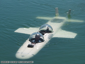
By Steve Almasy
Most people have had dreams of flying. Graham Hawkes had dreams of flying -- underwater. Hawkes has been in the business of building underwater craft for more than a decade. In the early days, his company, Hawkes Ocean Technologies, built vehicles for researchers and moviemakers.
But in the past few years, the ultrarich have increasingly looked for cool playthings for their ocean adventures. What better toy to have on the end of your 200-foot yacht than a submarine capable of diving to 1,500 feet below the sea's surface ?Whoops. Did we say submarine ? It's a submersible that can "fly" underwater.
The Deep Flight Super Falcon looks like a fighter jet, with its thin body, two seats, two sets of wings and two tail fins.
"We just had to tear up everything we knew about submersibles and start again on winged subs -- underwater flying machines," Hawkes said.
He said Deep Flight submersibles are designed to be more agile than any creature living in the ocean -- with the exception of dolphins.The company says that because of the wings, the Super Falcon can go barrel-rolling with dolphins while traveling at speeds much faster than other private submarines.
-
The navy has a top-secret vessel it wants to put on display
- On 26/02/2009
- In Marine Sciences
- 0 comments

By Barry Newman
Anybody want some top-secret seagoing vessels ? The Navy has a pair it doesn't need anymore. It has been trying to give them away since 2006, and they're headed for the scrap yard if somebody doesn't speak up soon.
One is called Sea Shadow. It's big, black and looks like a cross between a Stealth fighter and a Bat mobile. It was made to escape detection on the open sea.The other is known as the Hughes (as in Howard Hughes) Mining Barge. It looks like a floating field house, with an arching roof and a door that is 76 feet wide and 72 feet high. Sea Shadow berths inside the barge, which keeps it safely hidden from spy satellites.
The barge, by the way, is the only fully submersible dry dock ever built, making it very handy -- as it was 35 years ago -- for trying to raise a sunken nuclear-armed Soviet submarine."I'm fascinated by the possibilities," Frank Lennon said one morning recently. Mr. Lennon runs -- or ran -- a maritime museum here in Providence. He was standing in a sleet storm on a wharf below a power plant, surveying the 297-foot muck-encrusted hulk of a Soviet submarine that he owns.
His only exhibit, it was open to the public until April 2007, when a northeaster hit Providence and the sub sank.
-
NOAA offers new online media library
- On 12/02/2009
- In Marine Sciences
- 0 comments

From NOAA
NOAA’s Office of National Marine Sanctuaries has launched a new online multimedia library offering public access to thousands of high-resolution, ocean-related photos and videos taken by NOAA scientists, educators, divers and archaeologists.
“This robust online library offers thousands of images from all 14 marine protected areas managed by NOAA,” said Michiko J. Martin, national education coordinator for NOAA’s Office of National Marine Sanctuaries. “Some of these images depict threats and human pressures on marine life in a compelling fashion that we hope will inspire ocean literacy and conservation.”
The National Marine Sanctuaries Media Library is a comprehensive database containing a collection of high-quality still images and video footage featuring all 13 national marine sanctuaries and the Papahānaumokuākea Marine National Monument.The database is fully searchable by keyword, category and location, and all the images are tagged with relevant information including resolution and usage rights.
-
Danube delta holds answers to "Noah's Flood" debate
- On 24/01/2009
- In Marine Sciences
- 0 comments
From The Woods Hole Oceanographic Institution
Did a catastrophic flood of biblical proportions drown the shores of the Black Sea 9,500 years ago, wiping out early Neolithic settlements around its perimeter ?A geologist with the Woods Hole Oceanographic Institution (WHOI) and two Romanian colleagues report in the January issue of Quaternary Science Reviews that, if the flood occurred at all, it was much smaller than previously proposed by other researchers.
Using sediment cores from the delta of the Danube River, which empties into the Black Sea, the researchers determined sea level was approximately 30 meters below present levels—rather than the 80 meters others hypothesized.
“We don’t see evidence for a catastrophic flood as others have described,” said Liviu Giosan, a geologist in the WHOI Geology and Geophysics Department.
Ten thousand years ago, at the end of the last glacial period, the Black Sea was a lake—cut off from the Sea of Marmara and beyond it the Mediterranean by the Bosphorus sill.Debate in geological and archaeological circles has focused on whether, as glaciers melted and global sea levels began to rise, the Bosphorus sill overflowed gradually or whether a flood broke through the sill, drowning some 70,000 square kilometers and wiping out early Neolithic civilizations in the region.
In addition to questions about the rate of the flood, investigators continue to debate the extent of the flood -- a debate centered around what the level of the Black Sea was 9,500 years ago.
In the late 1990s, Columbia University researchers Bill Ryan and Walter Pitman examined the geological evidence and estimated the Black Sea level at the time of the flood was approximately 80 meters lower than present day levels.They suggested that the impact of a Black Sea flood could have forced the movement of early agriculturist groups to central Europe and established the story of Noah and his ark, as well as flood myths among other peoples.
-
The Oculus 250-foot superyacht is half boat, half cyber whale
- On 09/12/2008
- In Marine Sciences
- 0 comments
From Dvice
Probably now more than ever with the global economy the way it is, designer E. Kevin Schöpfer's "Oculus" yacht is the stuff of dreams.
Yet dreamy it is. At 250 feet long and featuring 12-foot ceilings, it's one roomy way to travel over the high seas at 25 knots.
Its hull is prominently styled after the creatures of the sea, with an open-mouth-like backside and something looking a bit like an eye socket.
The Oculus is just a concept, but it's the flagship design for Schöpfer's new yacht line. -
Underwater vehicles may change what we know about our reefs
- On 05/12/2008
- In Marine Sciences
- 0 comments

By Tyler TreadwayBefore two brand-new, first-of-their-kind autonomous underwater vehicles begin exploring the depths of the world's oceans, they'll get their feet wet in the water off the Treasure Coast.
Known as AUVs, the unmanned, untethered submarines will be aboard the Seward Johnson, a research vessel of the Fort Pierce-based Harbor Branch Oceanographic Institute, when it sets sail today on a mission to create high-definition sonar maps of the deep-water Lophelia coral reefs.
The Lophelia reef mapping is particularly important because the coral is threatened by bottom-trawling fishing boats and possible offshore oil exploration and drilling.
"If you destroy reef, you destroy habitat," said John Reed, a research professor at the Harbor Branch division of Florida Atlantic University who has been studying and working to protect these deep corals for more than 30 years. "And if you destroy habitat, you destroy fisheries. So by fishing on these reefs, we're shooting ourselves in the foot." -
We all live in a solar submarine
- On 03/12/2008
- In Marine Sciences
- 0 comments

By Keith Barry
If playing with electricity underwater doesn't seem crazy enough, a Swiss company is suggesting an even more mind-boggling combination: the world's first solar submarine. We wonder if they've designed windows that open.
Energy giant BKW-FMB is looking for investors ready to pony up almost $9 million to start work on Project Goldfisch, which consists of a floating Goldport "power island" of photovoltaic panels that will channel electricity to the submersibles running below.
Since the price tag on your average nuclear-powered Virginia-class sub starts at around $2.5 billion, we suspect BKW will spend its investment on a newer copy of Photoshop. The laughable renderings the company provided were obviously worked out on an Amiga.
As for the sub itself, someone at BKW has an incredible sense of humor and a penchant for late 70's Bond films or the company is anticipating a rise in the number of villains needing awesome hideouts. Either way, we're ready to jump in the submersible Lotus Esprit and pop a Carly Simon cassette in the tape deck.
The company says the sub would draw power from a floating solar array of five generators, each with 430-square feet of panels. A GPS tracking system would tell the sub where to surface when it needs to recharge, which makes us wonder — would a dead Goldfisch float belly-up ? Once charged, BKW says, the sub could dive to depths approaching 1,000 feet and reach a top speed of 5 knots (not quite 6 mph). -
Hidden depths of our planet
- On 09/11/2008
- In Marine Sciences
- 0 comments
By Grace Hammond
Far beneath the waves off the coast of the Bahamas lies the Black Hole of Andros and it does not sound like a lot of fun.
Paul Rose says: "There's a layer of bacterial matter 18m down, it's incredibly oily and, as you enter, you lose all visibility.It's unusual to smell anything underwater but, because your skin absorbs it, you can smell it – like rotten eggs. It's also baking hot, about 35º C, and you get quite disorientated."
Paul is a former vice president of the Royal Geographical Society, the base commander of the British Antarctic Survey base and is now the presenter of Oceans, an eight-parts series that covers maritime archaeology, biology, conservation, history and culture.
A breezy east Londoner, who began diving in 1969, Paul ventured into the black hole in search of evidence about how the oceans work. Located in the part of the Atlantic Ocean from which the Gulf Stream springs, it offers an insight into a past world – a snapshot of what the oceans were like three-and-a-half billion years ago."I've really wanted to present a series about great diving expeditions with great settings," he says.
"I've always been inspired by slightly-old fashioned films, along the lines of the programmes that first inspired me to dive, like the great Jacques Cousteau expeditions and the adventure series Sea Hunt."
-
Small islands given short shrift in assembling archaeological record
- On 01/11/2008
- In Marine Sciences
- 0 comments

From Science Daily
Small islands dwarf large ones in archaeological importance, says a University of Florida researcher, who found that people who settled the Caribbean before Christopher Columbus preferred more minute pieces of land because they relied heavily on the sea.
“We've written history based on the bigger islands,” said Bill Keegan, a University of Florida archaeologist whose study is published on line in the journal Human Ecology. “Yet not only are we now seeing people earlier on smaller islands, but we're seeing them move into territories where we didn't expect them to at the time that they arrived.”
Early Ceramic Age settlements have been found in the U.S. Virgin Islands and Montserrat, for example, but are absent from all of the larger islands in the Lesser Antilles, Keegan said.
And all of the small islands along the windward east coast of St. Lucia have substantial ceramic artifacts — evidence of settlement — despite being less than one kilometer, or .62 mile, long, said Keegan, who is curator of Caribbean archaeology at the Florida Museum of Natural History on the UF campus.
Read more... -
Odyssey IV - Underwater Robot
- On 22/10/2008
- In Marine Sciences
- 0 comments
From TFOT
MIT researchers have designed an underwater robotic craft dubbed Odyssey IV. This new, small, and inexpensive vehicle is capable of hovering in place much like a helicopter.
In addition, it can move in a speed of up to two meters per second going straight ahead, giving it another advantage.
Odyssey IV can prove to be a valuable scientific instrument for deep water oil explorers, marine archaeologists, and oceanographers.
Odyssey IV differs from previous artificially intelligent submarines developed by the MIT Sea Grant College program's Autonomous Underwater Vehicles Laboratory, in that it can hover in place and doesn't need to keep moving forward at all times.
When stopping, Odyssey keeps correcting itself for currents and obstacles, thus holding its position, enabling it to make detailed inspections or to photograph the flora and fauna around an undersea vent.
Read more... -
Virtual submarine that will allow access to Europe's sunken wrecks
- On 10/09/2008
- In Marine Sciences
- 0 comments
By James Randerson
Archaeologists are creating a permanent digital record of shipwrecks around European coasts.By recording the precise 3D arrangement of timbers and cargo from the wrecks the researchers aim to preserve the information they contain about past civilizations even if the wrecks are damaged or destroyed.
Scientists and members of the general public would in future be able to float over the wrecks in a virtual submarine from the comfort of their own desks. For researchers, this would allow them to explore the wreck and make decisions about future excavations without spending large amounts of money going out to sea.
So far the €2.2m Venus (Virtual Exploration of Underwater Sites) project, which involves 11 different institutions across Europe, has created a digital representation of two shipwrecks; one a Roman ship dating from around AD200 off the island of Pianosa near the Tuscan coast and the other, the Barco da Telha, a pre-18th century vessel that sank off the Portuguese coast near Sessimbra.
There are already plans to begin mapping another Roman wreck off Marseilles.
Read more... -
Explorers Club Flag Expedition creates world's first underwater biodiversity map
- On 05/09/2008
- In Marine Sciences
- 0 comments
By Larry Smith
In the early years of the 20th century the Explorers Club was one of the hottest gigs around.
Back then its membership included men like Robert Peary and Matthew Henson - the white and black Americans who first reached the North Pole in 1909 (with the help of a few eskimos).
Sir Edmund Hillary, the New Zealander who was the first to climb Mt Everest in 1953 with the Nepalese sherpa Tenzing Norbay, was the club's honorary chairman for decades.
And astronauts Neil Armstrong and Buzz Aldrin took the Explorers Club flag with them on the first trip to the moon in 1969.
In fact, a good number of the 20th century’s most influential adventurers were members of this society, whose New York headquarters contains a treasure trove of exploration artifacts and memorabilia.
Over the years the Explorers Club has sponsored hundreds of expeditions. And one of the most recent was to the Bahamas - to Peterson Cay National park off the coast of Grand Bahama to be exact.
Read more... -
First underwater view of Northern Ireland coastline is webcast
- On 07/06/2008
- In Marine Sciences
- 0 comments
From Public Technology
An European funded project to survey the seabed off the northern coast of Ireland, parts of which have not been surveyed since Victorian times, has started to provide some spectacular results showing underwater cliffs, reefs, caves and what may have been a lagoon.The wreck of a ship which sank in 1918 has also been discovered. Survey operations started in November last year and vessels using modern multi-beam echo sounding technology have been surveying a 3 nautical mile coastal strip westward from Country Antrim, around Rathlin Island to Inishtrahull Island off Donegal.
Those results have now been collated into a graphical display.
The data gained will be used to provide more accurate navigational charts and to study the topography of the sea floor.
The Joint Irish Bathymetric Survey (JIBS) Project is being led by the Maritime and Coastguard Agency in partnership with the Marine Institute of Ireland. This E2.1m joint venture is being entirely funded by the EU from their INTERREG Programme, which is co-ordinated by the Department of the Environment for Northern Ireland.
-
University of Haifa opens unique School of Marine Sciences
- On 06/06/2008
- In Marine Sciences
- 0 comments
By Meira Faratci
The University of Haifa has inaugurated the Leon Charney School of Marine Sciences, the first in the world to integrate research in marine biology, marine geophysics, marine and coastal history, and marine civilization.The establishment of the school on Tuesday was made possible by an $8 million donation from the chairman of the university's board of governors, Leon Charney. Marine biology studies at the school will include research on micro-organisms, algae, and marine animal behavior conducted in the bodies of water surrounding Israel.
The marine geophysics department will investigate how to best utilize the country's 300 kilometers of coastline.
An exploration of the archaeological and geological aspects of Israel's oceans and rivers will be conducted by the department of marine and coastal history.
Most unique to the university, the department of marine civilization will focus on the sociological influences of marine environments on the societies which they surround.