Dangerous Places for Shipping
Dangerous Places for Shipping News
-
Nazi chemical weapons leaking into the Baltic Sea
- On 27/04/2014
- In Dangerous Places for Shipping
- 0 comments

By Johnny Duggan - Riot NewsNext May marks the 70th anniversary of V-E day and the end of the second World War. During the post-war Potsdam Conference, it was mutually agreed upon by the Allies that the remaining 65 tonnes of Nazi chemical weapons would be disposed of in the Baltic Sea.
While their intentions were certainly good, it was clearly a decision made without a complete consideration of the long-term ramifications of such a method.
Now, those sunken stockpiles may be stirring up huge problems from their watery resting place.
Here’s what we know about them, what we don’t, and what kind of problems we could be facing.
65,000 tonnes roughly measures out to about 143 million pounds. To put that in perspective, it’s like having nearly 1,800 big-rig 18 wheelers just lying on the ocean floor.
But instead of hauling some type of consumer cargo, those trucks are filled with deadly chemicals and explosives.
The agreement reached during the Potsdam Conference stipulated that the weapons be dumped into the (relatively shallow) Baltic Sea. However, this stipulation wasn’t exactly followed to the letter.
Allegedly, Soviet ships would dump the weapons as soon as they were no longer visible from land, as opposed to disposing of them in the designated areas.
-
Forgotten Second World War U.S. shipwreck
- On 27/07/2013
- In Dangerous Places for Shipping
- 0 comments

By Dene Moore - Vancouver SunAlmost seven decades after a U.S. military transport ship sank to the ocean floor off the north coast of British Columbia, the Canadian Coast Guard has received approval to remove bunker oil and other potentially hazardous materials from the Second World War-era vessel.
The maritime safety agency issued a request for proposals on Friday for a contractor to tap into the rotting hull of the Brigadier General M.G. Zalinski where it lies 100 kilometres south of Prince Rupert, B.C., burping oil to the surface.
“This was a vessel that was lost, ran aground and sank. It was one of those dark and stormy nights in 1946,” said Roger Girouard, assistant commissioner of the western region for the coast guard.
The Zalinski was transporting ammunition and equipment to Alaska at the outset of the Cold War. The location of the wreck was consigned to history.
“There she sat for several decades,” Girouard said.
It lies under 34 metres of water, on the edge of a cliff in the Grenville Channel, a narrow and scenic waterway that sees as many as a half dozen ferries and cruise ships a day in the summer and countless commercial fishing vessels.
Reports said no crew members died when the ship went down in a blinding rain storm, and the wreck remained out of sight and out of mind until an oil slick was reported to the coast guard in 2003.
The agency located the source of the oil using an underwater remote-controlled vehicle, and later divers retrieved the ship’s bell to confirm her identity.
-
87 shipwrecks, most from WWII, could leak oil near US
- On 21/05/2013
- In Dangerous Places for Shipping
- 0 comments

By Seth Borenstein - Brandon SunA new government report details 87 shipwrecks — most sunk during World War II decades ago — that could pollute U.S. waters with tens of millions of gallons of oil.
Even so, the potential for pollution is less than scientists had expected. The report released Monday by the National Oceanic and Atmospheric Administration concludes "the scope of the problem is much more manageable than initially feared.... Our coastlines are not littered with 'ticking time bombs.'"
Agency officials estimate that far less oil will leak into the ocean than the BP oil spill of 2010, which spewed roughly 200 million gallons into the Gulf of Mexico alone.
"That's not a bad number in comparison to what we first thought it would be," said NOAA's Lisa Symons, who wrote the study.
There are 20,000 shipwrecked vessels that lie off the nation's coastlines. Most of those either finished leaking long ago, ran on coal instead of oil, are too small or aren't near vulnerable land.
"There are only six that really keep me up at night, but we don't know where they all really are," Symons said. Those six have the biggest potential to foul coastal areas because even if they spill only 10 per cent of their oil, they could cause a local-scale disaster, she said. They don't have to be a worst-case spill to be a disaster.
Of those six, Symons said NOAA doesn't know the exact location of three of them, just where they were last seen before they sank. Three of the six worst potential problems are off Florida, one near Georgia, one near South Carolina and one near New York. Some are as close as 15 miles from shore.
-
Philippines files charges against Chinese ship stuck on reef
- On 15/04/2013
- In Dangerous Places for Shipping
- 0 comments
By Simone Orendain - VOA News
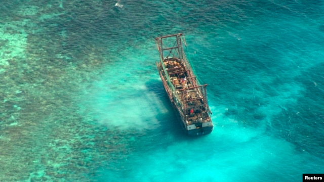
Philippine officials say 12 fishermen who were onboard a suspected Chinese ship are facing the first of several charges after their vessel got stuck on a major protected reef in the southwestern Philippines.
The Tubbataha Reefs Natural Park Management Office says the fishing vessel ran aground on an atoll close to the park rangers’ barracks.
Staff at the park took photographs of the suspected Chinese ship, which they say was equipped with fishing gear, but had no fish nor marine life on board.
Tubbataha Management spokeswoman Glenda Simon says this was enough to file the first charge of poaching, according to Philippine law.
“The mere presence of a fishing vessel inside a protected area, particularly Tubbataha, is prima facie evidence of fishing, even if they’re not caught fishing in the park,” she said.
Simon said further charges include unauthorized entry, damage to the reef and a corruption charge for an alleged bribe of $2,400 the fishermen are reported to have offered to park rangers to be set free.
The massive 97,000 hectare Tubbataha Reef in the Sulu Sea is a UNESCO World Heritage site, prized for its marine animal biodiversity. The reefs are popular with recreational divers. The region is far from reefs and islands in the South China Sea that are contested by China. -
Chinese fishing vessel runs aground on Tubbataha Reef
- On 10/04/2013
- In Dangerous Places for Shipping
- 0 comments
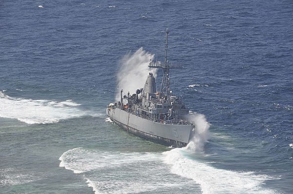
From gCaptainThe Philippine Coast Guard said Tuesday that a Chinese fishing vessel has run aground on the Tubbataha Reef, just ten days after the final section of the former USS Guardian was removed.
According to a report by the Tubbataha Management Office, the Chinese-flagged fishing vessel ran aground along the northern part of the UNESCO World Heritage Site late Monday night.
Authorities dispatched a search and rescue vessel Tuesday to assess the situation, including the condition of the vessel.
The 12 crewmembers on board, all said to be Chinese nationals, were transferred to the SAR vessel and will be turned over to the National Committee on Illegal Entrants in Palawan.
Tubbataha Reef is the same site where the USS Guardian ran aground on January 17 after having just completed a port call at Subic Bay in the Philippines.
-
World’s first underwater nuclear explosion
- On 24/02/2013
- In Dangerous Places for Shipping
- 0 comments
By Michael Zhang - Peta Pixel
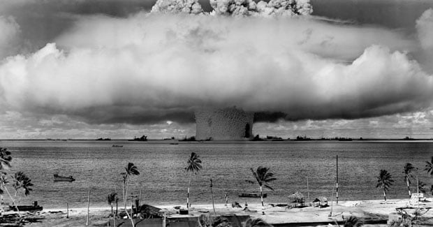
In in 1946, the United States conducted a series of nuclear weapon tests at Bikini Atoll in what’s known as Operation Crossroads.
A total of two bombs were detonated to test the effects nuclear blasts had on naval warships.
The second, named Baker, was the world’s first nuke to be detonated underwater.
Due to the unique properties of underwater explosions, the Baker test produced a number of unique photographs that the world had never seen before.
Read and see more...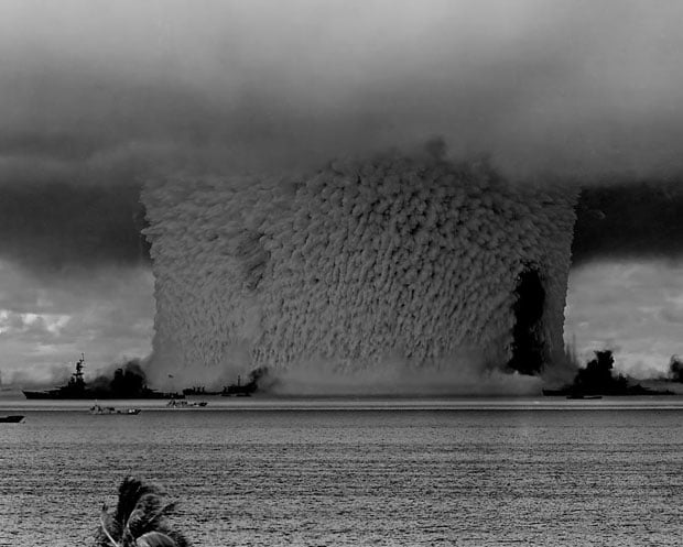
-
Praise for Kiwi divers involved in Rena clean up
- On 02/10/2012
- In Dangerous Places for Shipping
- 0 comments
By Grayson Ottaway - News Talk ZB
There's praise for Kiwi divers involved in the Rena clean up by an international salvage and recovery firm.
In seven days, the divers have manually loaded 81 tonnes of debris from around the wreck of Rena into cages, that are then hoisted up to the surface.
Braemar Howells operations manager Mike Richards says the men have been working in difficult conditions at depths down to 30 metres, often in strong currents.
-
'Nuclear time bomb:' Downed K-27 submarine must be lifted out
- On 14/09/2012
- In Dangerous Places for Shipping
- 0 comments

From RTA Soviet K-27 submarine suffered a nuclear accident before being dumped at the bottom of the Kara Sea 30 years ago.
Russia may now have to lift the sub from dangerously shallow waters – before an “uncontrolled chain reaction” causes fatal damage.“Radiation leakages will come sooner or later if we just leave the K-27 there. The sub has already been on the seafloor for 30 years, and it was rusty even before it was sunken. Leakages of radioactivity under water are nearly impossible to clean up,” Thomas Nilsen, a nuclear safety expert who has extensively mapped radioactive waste on the Arctic seabed, told RT.
Equipped with an experimental liquid-coolant nuclear engine, the K-27 was ill-fated from its launch in 1962. It made only three voyages, the last of which, in 1968, ended in tragedy.
A short way from its base in the Barents Sea, its reactor malfunctioned, and the brave but badly-trained crew made a futile attempt to fix it.
Instead of solving the problem, they were exposed to fatal doses of radiation.
Nine seamen died, most of them in hospital in agony from radiation sickness several days after the accident.
The incident was kept secret by the Soviet government for decades, and the families of the victims received no compensation.
After repeated plans to redesign the sub, Soviet authorities decided it was easier to dispose of it, and towed the vessel to a remote test site in the Kara Sea, near the Arctic Ocean, in 1981.
Although international guidelines say decommissioned vessels should be buried at least 3,000 meters under the sea, the Soviet Navy scuttled it at around 75 meters.
-
International team of 40 ready to remove Rena's bow
- On 31/07/2012
- In Dangerous Places for Shipping
- 0 comments
By Kiri Gillespie - NZ HeraldUp to 40 wreckage removal experts from around the world will converge on Tauranga in the next week for the second phase of the Rena recovery.
Salvage authorities announced plans to remove the bow section of the stricken cargo ship this week but said yesterday they were yet to figure out how to remove the rest of the Rena from Astrolabe Reef.
The ship ran aground on the reef as it headed towards Tauranga early on October 5, spewing oil and debris across the coast.
Clean-ups have helped clear remaining rubbish but the wreck remains on a 22-degree list on the reef in rough water described as like a washing machine.
The operation to remove the bow will begin on August 3 when a salvage team boards the ship and cuts the section into pieces.
Divers will cut around the bow up to 1m below the surface, using a combination of magnesium steel with oxygen and electricity to cut the metal.
-
A tour of Cape Cod shipwrecks
- On 30/06/2012
- In Dangerous Places for Shipping
- 0 comments
By Jack Sheedy - The Barnstable Patriot
The waters and sands around Cape Cod form the final resting place for hundreds of shipwrecks that occurred here over the past four centuries.
Dangerous shoals and bars along the backside of the peninsula snagged so many of these hapless vessels that 13 lifesaving stations were built to aid shipwrecked mariners. Eventually, the opening of the Cape Cod Canal in 1914 allowed vessels to avoid the treacherous Atlantic coastline and significantly reduced the number of disasters.
In fact, it is said that if all the vessels that came to woe here were lined up bow to stern they would form an unbroken chain from Monomoy to Provincetown. Many of these wrecks have become lost over time beneath the unceasing rhythms of sea and sand.
Others were picked over so thoroughly by Cape Codders of old that they no longer exist intact, but rather in pieces – perhaps as a door in a house or as boards forming an old barn.
A shipwreck along the shore in those days was a bounty from the sea to be scavenged by the locals. Nothing was left to waste. Yet, some memorable Cape wrecks, or pieces left behind from those wrecks, can still be viewed today – if you know where to look. And you won’t even need scuba gear.
To commence any tour of Cape Cod shipwrecks, one should start at the very beginning with the Cape’s first recorded shipwreck – the Sparrow-Hawk, which grounded off Nauset Beach in 1626.
Not only are her English elm keel and oak ribs viewable today, but these timbers are in remarkably good condition given their antiquity and the fact that they were exposed to the elements for more than 200 years.
The story of the Sparrow-Hawk mirrors that of the Mayflower – a voyage across the Atlantic Ocean in search of a new life in a new world.
Like the Mayflower, the Sparrow-Hawk arrived at Cape Cod, north of her intended destination at Virginia, and like the Mayflower, headed south along the coastline.
Unlike Captain Christopher Jones of the Mayflower, though, who realized the dangers of the shoals along the outer Cape and promptly turned his vessel around for the safety of Provincetown Harbor, the captain of the Sparrow-Hawk eventually wrecked his vessel.
All hands survived, spending the winter with the Pilgrims in Plymouth.
As for the wreck, it was said to be burned to the waterline by Natives and her remains became sanded in until they were discovered in the 1860s and exhumed to go on display around New England.
The ship’s skeletal timbers later landed at Pilgrim Hall in Plymouth, and are now on loan to the Cape Cod Maritime Museum in Hyannis, where they can be viewed.
Another museum in Barnstable that holds a remnant of an impressive shipwreck is the Centerville Historical Museum. On exhibit is the ship’s wheel from the 291-foot paddlewheel steamer, Portland, which sank during a terrible storm in November 1898 with some 175 people on board.
Wreckage from this disaster washed up all along the Lower Cape coastline, ending up in private homes and, eventually, in museums around the Cape, such as at the Jericho House Barn Museum in Dennis, where a Portland deck post is on display.
Provincetown’s Macmillan Wharf is home to the Expedition Whydah Sea Lab & Learning Center, where artifacts can be seen from the wreck of the pirate ship, Whydah, which foundered off Wellfleet in 1717.
The vessel was under the command of legendary pirate “Black” Sam Bellamy, who, as lore suggests, romanced an Eastham woman named Maria Hallett before setting off to make his fortune through piracy. During his return voyage to the area, Bellamy ran into a storm and his prize Whydah wrecked just off his former lover’s coast.
-
Devil's Nose was a 'graveyard of ships'
- On 21/12/2011
- In Dangerous Places for Shipping
- 0 comments
By Richard Palmer - Pall Times
More than two centuries ago, early in the development of commercial sailing, a particularly bad spot for shipwrecks was located a few miles west of Rochester at what today is Hamlin Beach State Park, then known as “Devil’s Nose.”
One of the first such mishaps occurred there more than two centuries ago. The location is approximately seven miles west of Braddock’s Bay, near Rochester.
The reason why so many wrecks occurred here is no mystery. Fortunately, no loss of life was been recorded.While the headland is easily spotted from the lake, there is — or was — a dangerous shoal extending outward from the shore, which was visible only during a heavy gale when the seas broke over it. Geologists say this shoal was the result of centuries of washing by waves and precipitation.
The Coast Pilot,” which was once the bible of navigators, warned sailors to keep half a mile off shore for good water as there was a “dirty spur” almost a mile east of Devil’s Nose, with only feet of draft on it, roughly three-eighths of a mile out.
Of the many vessels wrecked on Devil’s Nose, nearly all wound up there as a result of heavy weather, especially when the lake was fogged in. The ships would become hopelessly wedged in the boulders and break up like toothpicks.
This was the fate of the two-masted schooner Undine which was bound for Sodus on Nov. 1, 1890, and many others.
The first recorded shipwreck there was the Canadian schooner Duchess of York more than 213 years ago. About the only details existing of this wreck were reported in a newspaper published at Niagara-on-the-Lake, the Niagara Constellation, on Dec. 7, 1799:
“On Thursday last, Nov. 29th, a boat arrived here from Schenectady. She passed the York, sticking on a rock off the Devil’s Nose. No prospect of getting her off.A small deckboat also, she reports, lately sprung a leak 12 miles distant from Oswego. The people on board, many of whom were passengers, were taken off by a vessel passing, when she instantly sank. Cargo is lost.”
Later, on Dec. 21, 1799, another newspaper, the Upper Canada Gazette, reported:
“We hear from very good authority that the schooner York, Captain Murray, has foundered and is cast upon the American shore about 50 miles from Niagara, where the captain and men are encamped. Mr. Joseph Forsyth, one of the passengers, hired a boat to carry them to Kingston.”
Forsyth had been a merchant at Niagara since 1793 when he arrived aboard the lake’s earliest private merchant vessel, Dorchester. The vessel was 80 tons, and built near Kingston in 1787.